Located between South 72nd Street and South 16th Street in Milwaukee and West Allis | National or State Registers Record | Wisconsin Historical Society

National or State Registers Record

Located between South 72nd Street and South 16th Street in Milwaukee and West Allis

National or State Register of Historic Places
Located between South 72nd Street and South 16th Street in Milwaukee and West Allis | National or State Registers Record | Wisconsin Historical Society
NAMES
Historic Name:Kinnickinnic River Parkway
Reference Number:11000462
PROPERTY LOCATION
Location (Address):Located between South 72nd Street and South 16th Street in Milwaukee and West Allis
County:Milwaukee
City/Village:MilwaukeeWest Allis
Township:
SUMMARY
Kinnickinnic River Parkway
Located between South 72nd Street and South 16th Street, Milwaukee and West Allis, Milwaukee County
Designer: Alfred Boerner

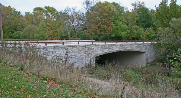
The Kinnickinnic River Parkway Historic District is located in Milwaukee with a small portion located in the neighboring community of West Allis in Milwaukee County. As part of the Milwaukee County Parkway System, it follows the Kinnickinnic River and connects Jackson Park and Pulaski Park. Charles B. Whitnall included the Kinnickinnic River Parkway in his 1923 study of a county-wide parkway system, which was conceived to promote the sanitary, health, and aesthetic benefits of urban parklands. Alfred Boerner, a Milwaukee County landscape architect and Wisconsin native, was instrumental in developing the plans for the parkway system, including the Kinnickinnic River Parkway. Although land acquisition for the Parkway began in 1926, it was not implemented until 1934 when federal work relief efforts made development possible. Works Progress Administration (WPA) labor was responsible for creek relocation and erosion control, road grading, bridge and road construction, and landscaping.

The Kinnickinnic River Parkway remains historically intact and conveys the original design intentions as a parkway component within the county-wide system. It is a strong example of parkway design, and continues to reflect the themes of community planning and development, federal work relief programs, and landscape architecture in the early twentieth century Milwaukee County Parkway System.

PROPERTY FEATURES
Period of Significance:1934-1960
Area of Significance:Community Planning And Development
Area of Significance:Landscape Architecture
Applicable Criteria:Event
Applicable Criteria:Architecture/Engineering
Historic Use:Recreation And Culture: Work Of Art (Sculpture, Carving, Rock Art)
Historic Use:Recreation And Culture: Sport Facility
Historic Use:Landscape: Park
Historic Use:Transportation: Road-Related
Architectural Style:Other
Resource Type:District
Architect:Boerner, Alfred
DESIGNATIONS
Historic Status:Listed in the National Register
Historic Status:Listed in the State Register
National Register Listing Date:07/14/2011
State Register Listing Date:08/20/2010
NUMBER OF RESOURCES WITHIN PROPERTY
Number of Contributing Buildings:10
Number of Contributing Sites:3
Number of Contributing Structures:14
Number of Contributing Objects:2
Number of Non-Contributing Sites:3
Number of Non-Contributing Structures:14
Number of Non-Contributing Objects:0
RECORD LOCATION
National Register and State Register of Historic Places, State Historic Preservation Office, Wisconsin Historical Society, Madison, Wisconsin

How to Cite

For the purposes of a bibliography entry or footnote, follow this model:

National Register of Historic Places Citation
National Register of Historic Places, "Historic Name", "Town", "County", "State", "Reference Number".

Have Questions?

If you didn't find the National Register listing you were looking for or have other questions about the National Register, please email us and we can help: