Filter: Categories of Wisconsin Historical Images
Filter: FORMAT_TYPE of drawings
Filter: Subject of water
Filter: Categories of Wisconsin Historical Images
Filter: FORMAT_TYPE of drawings
Filter: Subject of water

| Date: | 1936 |
|---|---|
| Description: | This map is red and black ink on tracing cloth and is oriented with north to the upper left. This hand-drawn map shows a central portion of the military ro... |
| Date: | 05 27 1849 |
|---|---|
| Description: | The wagon train crossing Laramie Creek in Wyoming. |

| Date: | 10 1852 |
|---|---|
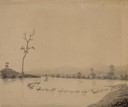
| Description: | Landscape view of the river looking downstream from Fort Snelling, Minnesota Territory. An expanse of placid river water fills the center of the drawing an... |

| Date: | 06 24 1849 |
|---|---|
| Description: | Original wash drawing of Fort Laramie, Wyoming (actually Fort John; see note below). Sketched by Wilkins on his 151-day journey from Missouri to California... |

| Date: | 1834 |
|---|---|
| Description: | Peck-a-ton-oka (Pecatonica River) with Rodolf farm in the background. |

| Date: | 1744 |
|---|---|
| Description: | A map of a plan of 16,500 acres of land. |

| Date: | 1851 |
|---|---|
| Description: | Plat map of the Town of Madison (Township 7N, Range 9E), from Volume 4, Federal Survey Plat Books. |

| Date: | 1872 |
|---|---|
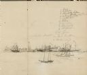
| Description: | The sidewheel packet, Red Wing, in the Mississippi River near Queen's Bluff below Trempealeau, Wisconsin. |

| Date: | 1780 |
|---|---|
| Description: | Hand-drawn plan for the layout of the town of Clarksville, bordering Mayfield Creek and Liberty Creek. Fort Jefferson is shown between the townsite and the... |

| Date: | 02 21 1874 |
|---|---|
| Description: | African American boatmen run a rapids in a small river boat. |

| Date: | 1832 |
|---|---|
| Description: | Hand-drawn map in two parts of the route of Governor J.D. Doty. Probably made by Doty in 1832 as a result of his travels with Alexander J. Center. |

| Date: | 1852 |
|---|---|
| Description: | Pencil drawing of Madison landscape as seen from University Hill. The main street in the center is State Street, and the building with Greek columns in the... |

| Date: | 1852 |
|---|---|
| Description: | Pencil drawing of view overlooking Madison. The sketch looks down North Hamilton Street from the capitol. Rutted, irregular streets and frame houses mark ... |

| Date: | 1862 |
|---|---|
| Description: | Sketch of Boone's Knob and the Kentucky River, where Company A of the 22nd Wisconsin Infantry camped, November-December, 1862. The sketch was drawn by Priv... |

| Date: | |
|---|---|
| Description: | Colorized view depicting the Wisconsin Central Railroad bridge at Stevens Point, with several men standing on top of the bridge painting the structure. Cap... |

| Date: | 1790 |
|---|---|
| Description: | Map of the region surrounding Dayton, Ohio showing rivers and other settlements, with a table of distances from Cincinnati to Dayton and to points outside ... |
| Date: | 1875 |
|---|---|
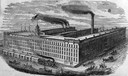
| Description: | Drawing of the C.H. & L.J. McCormick Reaper Manufactory (McCormick Reaper Works). The factory was built after the Chicago Fire of 1871 destroyed the origin... |

| Date: | 1833 |
|---|---|
| Description: | Map of part of the military road from Fort Crawford to Fort Howard. "Recorded on pages 668.669 Book B." Surveyed by Lieut. Center. Scale: 2 miles = 1 inch. |
If you didn't find the material you searched for, our Library Reference Staff can help.
Call our reference desk at 608-264-6535 or email us at: