 Filter: Categories of Wisconsin Historical Images
Filter: FULL_DATE of 1836
Filter: Subject of land
Filter: Categories of Wisconsin Historical Images
Filter: FULL_DATE of 1836
Filter: Subject of land

| Date: | 1836 |
|---|---|
| Description: | Map of the northern parts of Ohio, Indiana, and Illinois with Michigan and the part of "Ouisconsin" lying east of the Mississippi River. |

| Date: | 1836 |
|---|---|
| Description: | Woodcut of Prairie du Chien in 1836. Text at bottom reads: "Prairie du Chien in 1836. From an old cut." |

| Date: | 1836 |
|---|---|
| Description: | This map depicts Wisconsin and Michigan territories in 1836. It includes the area from Michigan to the Missouri River and Lake Winnipeg, and it shows the e... |

| Date: | 1836 |
|---|---|
| Description: | This hand-colored manuscript map shows the township and section grid in southeastern Wisconsin, covering the area west to Sugar River and Four Lakes region... |

| Date: | 1836 |
|---|---|
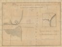
| Description: | A detailed map of the mouth of the Kewaunee River, showing the geological composition of the Lake Michigan shoreline and the various water depths in the ar... |

| Date: | 1836 |
|---|---|
| Description: | A series of ink, watercolor, and pencil on paper, hand-drawn maps of the townships of Darlington and Gratiot in Lafayette County, Wisconsin, showing the to... |
| Date: | 1836 |
|---|---|
| Description: | A hand-drawn map of the mouth of the Manitowoc River at Lake Michigan, showing depth of the water by contour lines. The included inset map shows the region... |

| Date: | 1836 |
|---|---|
| Description: | This manuscript shows the 1835 survey of the road corresponding approximately to a portion of County Trunk A in the Town of Scott, Brown County, Wisconsin.... |

| Date: | 1836 |
|---|---|
| Description: | Map shows rivers, creeks, roads, trails, mills, and town of Madison. Includes significant manuscript annotations; Sheet 1 is watercolor on lithographed map... |

| Date: | 1836 |
|---|---|
| Description: | Pencil on tracing paper. Rough sketch of Milwaukee. Left top corner reads: "From Map of northern part of Illinois and the surveyed part of Wisconsin Territ... |

| Date: | 1836 |
|---|---|
| Description: | This map shows settlers houses and businesses, trails, and swamps. The relief is shown by hachures. The map includes illustrations of historical buildings ... |

| Date: | 1836 |
|---|---|
| Description: | This map is pen-and-ink on paper and shows marshlands, rivers, creeks, a quarry, and a few roads. |
| Date: | 1836 |
|---|---|
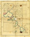
| Description: | Ink and watercolor on tracing paper. Shows townships 8 through 6, ranges 9 through 11 east, in Dane County. Lakes are labelled: "First Lake, Second Lake, T... |

| Date: | 1836 |
|---|---|
| Description: | This map of Navarino shows a development plat of the village situated opposite Fort Howard at mouth of the Fox River. The names of proprietors are listed a... |

| Date: | 1836 |
|---|---|
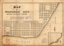
| Description: | This map show plat of the city, local streets, block numbers, section lines, and canals. The map includes reference text: "Surveyor's office, Brown County ... |
| Date: | 1836 |
|---|---|
| Description: | This map shows proposed lot and block numbers for a paper city located in township 10 north, range 7 east, Wisconsin Territory, now the Town of West Point,... |

| Date: | 1836 |
|---|---|
| Description: | This is a cadastral map and shows proposed lot and block numbers for a paper city on the banks of the Rock River. Also shown are two public squares and som... |

| Date: | 1836 |
|---|---|
| Description: | This map shows Havre Bay, a part of Maumee Bay, parts of Indian Island, Gard’s Island (Michigan), the Ottawa River, Vance River, creeks, and Ottawa Point (... |
| Date: | 1836 |
|---|---|
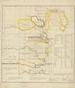
| Description: | This map shows rivers, roads, military posts, and geographical locations by tribe. Includes treaty notes and tables of Indian population statistics by trib... |

| Date: | 1836 |
|---|---|
| Description: | This negative photostat map shows the "oak tree, place of beginning" on the division line between Stockbridge and Brothertown Indians, and Governor Porter'... |
If you didn't find the material you searched for, our Library Reference Staff can help.
Call our reference desk at 608-264-6535 or email us at: