Filter: Categories of Wisconsin Historical Images
Filter: FULL_DATE of 1861
Filter: Subject of human settlements
Filter: Categories of Wisconsin Historical Images
Filter: FULL_DATE of 1861
Filter: Subject of human settlements
| Date: | 1861 |
|---|---|
| Description: | Soldiers in formation at Camp Randall during winter. The season [there appears to be snow on the ground] and the tents indicate that this image was made in... |

| Date: | 1861 |
|---|---|
| Description: | Drawn the first year of the Civil War, this colored 1861 map of Dane County shows its towns, cities and lakes. It includes insets of the wards of Madison a... |
| Date: | 1861 |
|---|---|
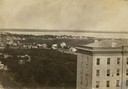
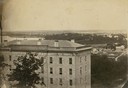
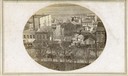
| Description: | View of Madison from Main Hall, now Bascom Hall, on the University of Wisconsin-Madison campus. South Hall is in the foreground, with several residences an... |
| Date: | 1861 |
|---|---|
| Description: | View of Madison from Main Hall, now Bascom Hall, on the University of Wisconsin-Madison campus. South Hall is in the foreground with several residences an... |

| Date: | 1861 |
|---|---|
| Description: | View of Madison from Main Hall, now Bascom Hall, on the University of Wisconsin-Madison campus looking up State Street toward the second Wisconsin State Ca... |
| Date: | 1861 |
|---|---|
| Description: | View of Madison from Main Hall, now Bascom Hall, on the University of Wisconsin-Madison campus. North Hall is in the foreground with several residences and... |

| Date: | 1861 |
|---|---|
| Description: | Bird's-eye map of Fond du Lac, "drawn after nature," with a parade of soldiers marching down the street. |
| Date: | 1861 |
|---|---|
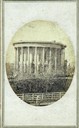
| Description: | Wisconsin Territorial Capitol (first in Madison) viewed from State Street. The back wall of the east wing of the replacement capitol (second on the site) c... |
| Date: | 1861 |
|---|---|
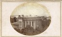
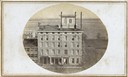
| Description: | East (King Street) wing of the third Wisconsin State Capitol and the south wall of the Territorial Capitol (at the left) taken from the roof of the buildin... |
| Date: | 1861 |
|---|---|
| Description: | East wing of the third Wisconsin State Capitol building (second in Madison) photographed from the U.S. Hotel building which was located at the corner of Ea... |
| Date: | 1861 |
|---|---|
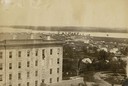
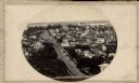
| Description: | First block of East Main street photographed from the roof of the Wisconsin State Capitol building. Doty and Wilson street properties and Lake Monona are i... |
| Date: | 1861 |
|---|---|
| Description: | The Vilas Hotel located at the corner of Monona Avenue at the west end of the first block of East Main Street. |
| Date: | 1861 |
|---|---|
| Description: | View up State Street looking toward the Wisconsin State Capitol from the roof of University Hall (later Bascom Hall), about 1860 or 1861. Actually the pho... |
| Date: | 1861 |
|---|---|
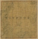
| Description: | Dane County plat map of the town of Windsor. |
| Date: | 1861 |
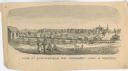
|---|---|
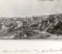
| Description: | "View of Springfield, MO. Frmonts [sic] Army in Possesion [sic]." Several people and a horse are in the foreground, and city buildings are in... |
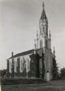
| Date: | 1861 |
|---|---|
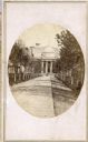
| Description: | The First Universalist Church, built in 1861. |

| Date: | 1861 |
|---|---|
| Description: | A map of Wisconsin showing cities, counties, major roads, railroads, and bodies of water. Includes an inset of the vicinity of Milwaukee. |
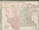
| Date: | 1861 |
|---|---|
| Description: | Colton's map showing Minnesota and the Dakotas. |

| Date: | 1861 |
|---|---|
| Description: | A hand-drawn poster, produced by S.W. Martin's Writing Academy of Madison, listing the officers and men of the 1st Regiment, Wisconsin Volunteer Infantry, ... |
If you didn't find the material you searched for, our Library Reference Staff can help.
Call our reference desk at 608-264-6535 or email us at: