 Filter: Categories of Wisconsin Historical Images
Filter: Subject of Aids to navigation
Filter: Categories of Wisconsin Historical Images
Filter: Subject of Aids to navigation

| Date: | |
|---|---|
| Description: | Hand-colored postcard view of the Reef Lighthouse in Lake Michigan off the shore of Racine. A person is standing to the left of the lighthouse. Caption rea... |
| Date: | 1910 |
|---|---|
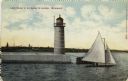
| Description: | Hand-colored postcard view of a pier and lighthouse at the entrance to Milwaukee's harbor. Two people sail in a small boat to the right of the lighthouse, ... |
| Date: | |
|---|---|
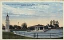
| Description: | Hand-colored postcard view of the lighthouse and boathouse at Bray's Point. Caption reads: "Bray's Point and Light, Junction of Fox River with Lake Winneba... |
| Date: | |
|---|---|
| Description: | View of ice coated pier and lighthouse along the shore of Lake Michigan. Caption reads: "Winter Scene at Port Washington, Wis." |
| Date: | |
|---|---|
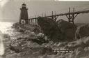
| Description: | Postcard view along icy shoreline of the pier and lighthouse on Lake Michigan at Port Washington in winter. |
| Date: | |
|---|---|
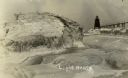
| Description: | Winter postcard view of the pier and lighthouse at Port Washington seen from the icy shore of Lake Michigan. Caption reads: "Light House." |
| Date: | |
|---|---|
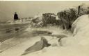
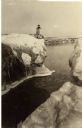
| Description: | Winter view of the lighthouse at Port Washington from the icy shore of Lake Michigan. Two people can be seen standing on a pier in the distance. |

| Date: | 1910 |
|---|---|
| Description: | Postcard view of three men on an elevated walk on an icy pier near the shoreline. A women and young boy stand on the pier below the walk. There is a lighth... |

| Date: | 1891 |
|---|---|
| Description: | Photograph of a painting by May Conniff Frost showing the tugboat Record of the Inman Line pulling a lake schooner through rough waters into Superio... |

| Date: | 1909 |
|---|---|
| Description: | This 1909 chart of the Apostle Islands, Chequamegon Bay, and the Lake Superior shoreline shows relief by contours and spot heights and depths by contours, ... |

| Date: | 1900 |
|---|---|
| Description: | This chart of the northern Apostle Islands and Lake Superior shoreline shows relief by contours and spot heights and depths by contours, gradient tints and... |

| Date: | 1871 |
|---|---|
| Description: | Asaph Whittlesey arrived in Ashland in 1854, one of the earliest of the settlers who hoped the area would grow and make their fortunes. He drew this map of... |
| Date: | |
|---|---|
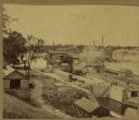
| Description: | Elevated view of a lock at Appleton, with views of mills and other structures in the background. |

| Date: | 1950 |
|---|---|
| Description: | This map of Sturgeon Bay is part of the survey of the northern and northwestern lakes. The map shows lights, railroads, roads, and some public buildings. R... |

| Date: | 1941 |
|---|---|
| Description: | Elevated view of Sturgeon Bay in 1900. Sturgeon Bay Bridge spans the bay and several boats are on the water. A lighthouse sits on a small island in the bay... |

| Date: | 1916 |
|---|---|
| Description: | This map shows Chequamegon Bay, an inlet of Lake Superior. Depths are shown by isolines and soundings and relief shown by contours. The map is colored in y... |

| Date: | 1901 |
|---|---|
| Description: | This map shows streets, industrial buildings, a portion of Lake Superior and other lakes, bays, and rivers in portions of Duluth and Superior. Relief is sh... |

| Date: | 1914 |
|---|---|
| Description: | This map shows streets, industrial buildings, a portion of Lake Superior and other lakes, bays, and rivers in portions of Duluth and Superior. Relief is sh... |
| Date: | 10 31 1930 |
|---|---|
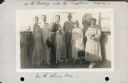
| Description: | Alma Seipp Hay, second from right, and her husband, William Sherman Hay, third from left, join Commander C.W. Berndtson and other passengers on the bridge... |

| Date: | 06 25 1901 |
|---|---|
| Description: | This map shows beacons, buoys, docks, quarries, streets, and buildings. The map inset shows the Harbor of refuge at entrance to Sturgeon Bay and Lake Michi... |
If you didn't find the material you searched for, our Library Reference Staff can help.
Call our reference desk at 608-264-6535 or email us at: