Filter: Categories of Wisconsin Historical Images
Filter: Subject of Battlefields
Filter: Creator Name of Unknown
Filter: Categories of Wisconsin Historical Images
Filter: Subject of Battlefields
Filter: Creator Name of Unknown
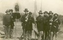
| Date: | 07 1863 |
|---|---|
| Description: | "Old Abe" and "Color Guard" of the Eighth Regiment, Wisconsin Volunteer Infantry, posed in uniform, outside with Old Abe on a shield perch. Likely Edward H... |
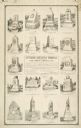
| Date: | |
|---|---|
| Description: | An advertisement by the Smith Granite Company showing illustrations of various Gettysburg Battleground Memorials. |
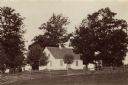
| Date: | 1890 |
|---|---|
| Description: | Site of the Battle to Antietam, The Dunker Church. A group of men stand among trees on the left. Horse-drawn carriages are under trees on the right. |
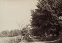
| Date: | 1890 |
|---|---|
| Description: | Hagerstown Pike. A brick wall and trees are along the road on the right. |
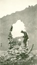
| Date: | |
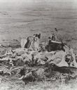
|---|---|
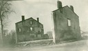
| Description: | A French house in ruins. Captioned: "Julian Bryan, standing in a hole made by a shell. Notice that French houses are constructed for centuries where Amer... |
| Date: | 1917 |
|---|---|
| Description: | Ruins of a French house. Captioned: "The first real ruins of the war that any of S.S.U. 12 ever saw. Our way to the front lead over the battlefield of th... |
| Date: | |
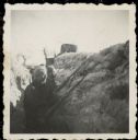
|---|---|
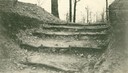
| Description: | Dirt stairs through the trench wall. Captioned: "Passages up which troops rush for an attack." |
| Date: | 06 1917 |
|---|---|
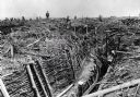
| Description: | British troops clear German trenches that were destroyed in battle in the Messine Ridge, Flanders. |
| Date: | |
|---|---|
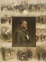
| Description: | A portrait of General Grant surrounded with scenes of his life. |
| Date: | 1922 |
|---|---|
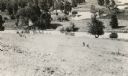
| Description: | The Pecatonica Battlegound marker, erected by the Rhoda Hinsdale Chapter of the Daughters of the American Revolution of Shullsburg and by the town of Wiota... |
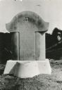
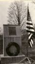
| Date: | 1945 |
|---|---|
| Description: | Marker on State trunk highway 78 near the intersection of Dane County Highway Y. A more recent official marker is about a mile away, at the intersection of... |
| Date: | |
|---|---|
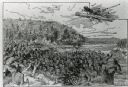
| Description: | An illustration titled "The Battle of the Brule" based on an 1840's battle between the Ojibwe and Dakota Sioux over territory in the Ashland, Wisconsin are... |
| Date: | 1930 |
|---|---|
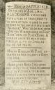
| Description: | View of the historic site marker on Highway 35 indicating the location of Bad Axe Battlefield. Caption reads: "Tablet on Highway #35 * Victory, Wis." |

| Date: | |
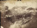
|---|---|
| Description: | Plan of the battle of the horse shoe bend on the East Pecatonica. |
| Date: | |
|---|---|
| Description: | The Battle of Chattanooga from the Milwaukee-based American Panoramic Company's cyclorama "The Storming of Missionary Ridge." |
| Date: | |
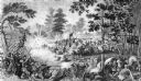
|---|---|
| Description: | Steel engraving of the first major battle of the Civil War, fought in Virginia, near the Manassas, Virginia, railway junction, after which the battle is ca... |
| Date: | |
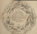
|---|---|
| Description: | A map of the second version of the Gettysburg cyclorama created by French artist Paul Philippoteaux, as taken from the souvenir booklet which sold for five... |
If you didn't find the material you searched for, our Library Reference Staff can help.
Call our reference desk at 608-264-6535 or email us at: