 Filter: Categories of Wisconsin Historical Images
Filter: Subject of Express highways
Filter: County of Milwaukee
Filter: Categories of Wisconsin Historical Images
Filter: Subject of Express highways
Filter: County of Milwaukee
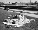
| Date: | 1965 |
|---|---|
| Description: | Women sun bathe near an express highway in Milwaukee. |
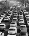
| Date: | 1957 |
|---|---|
| Description: | Elevated view of city traffic of bumper-to-bumper cars leaving Milwaukee County Stadium after the 1957 World Series. |
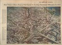
| Date: | 03 09 1965 |
|---|---|
| Description: | Aerial view and illustration of projected projects, including interstates and interchanges in downtown Milwaukee, for the 1970's. |

| Date: | 1975 |
|---|---|
| Description: | Aerial view of Milwaukee County Stadium and the intersection of US 41 and I-94. County Stadium was built in 1953 and demolished in 2001. Although undated... |

| Date: | 1965 |
|---|---|
| Description: | Aerial view of early construction at the Marquette Interchange in Milwaukee, the junction of Interstate Highways I94 and I43. Construction began in 1964, ... |

| Date: | |
|---|---|
| Description: | Aerial view of the first Marquette Interchange, photographed some time after its completion in 1968. |
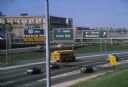
| Date: | 1981 |
|---|---|
| Description: | Fond du Lac Avenue (State Highway 145) exit from Interstate I-43 in Milwaukee. As originally conceived, the interstate system in Wisconsin was to consist ... |

| Date: | 04 01 1975 |
|---|---|
| Description: | The bridge over the Milwaukee Harbor named in honor of former Mayor Daniel Hoan. The bridge was constructed between 1970 and 1972, but during the period de... |
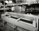
| Date: | 08 1948 |
|---|---|
| Description: | Exhibit in the Transportation Building at the Wisconsin Centennial Exposition, which included this model from the U.S. Public Roads Association. The model ... |
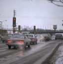
| Date: | 02 1977 |
|---|---|
| Description: | Automobile exhaust on a cold February morning in Milwaukee. |

| Date: | 1950 |
|---|---|
| Description: | Divided highway is South Chase Avenue between West Lincoln Avenue (2300) and East Oklahoma Avenue (3100). |

| Date: | 1922 |
|---|---|
| Description: | A road map of Milwaukee County, Wisconsin that shows the township and range system, towns, communities, completed roads, a proposed system of roads, steam ... |

| Date: | 1976 |
|---|---|
| Description: | A street map of Milwaukee County, Wisconsin that identifies the location of schools, hospitals, parks, beaches, streets, freeways, both planned or under co... |

| Date: | 1914 |
|---|---|
| Description: | A hand-drawn and colored map of the Milwaukee Township, showing how lands were used, included are parks, cemeteries, private grounds, and speculative land.... |

| Date: | 1960 |
|---|---|
| Description: | Color coded map in pink, yellow, blue, and brown of Milwaukee County State and County trunk highways. The map includes a legend of symbols: "STEAM RAIL ROA... |

| Date: | 1938 |
|---|---|
| Description: | Color coded map in pink, yellow, blue, and brown of Milwaukee County State and County trunk highways. The map includes a legend of symbols: "STEAM RAIL ROA... |

| Date: | 1961 |
|---|---|
| Description: | Evacuation route out of Milwaukee. View from the side of the road looking downhill towards the rear of a Wisconsin State Patrol cruiser parked on the right... |

| Date: | 1936 |
|---|---|
| Description: | Color coded map in pink, yellow, blue, and brown of Milwaukee County State and County trunk highways. The map includes a legend of symbols: "STEAM RAIL ROA... |

| Date: | 1937 |
|---|---|
| Description: | Color coded map in pink, yellow, blue, and brown of Milwaukee County State and County trunk highways. The map includes a legend of symbols: "STEAM RAIL ROA... |

| Date: | 1941 |
|---|---|
| Description: | Color coded map in pink, yellow, green, and brown of Milwaukee County State and County trunk highways. The map includes a legend of symbols: "STEAM RAIL RO... |
If you didn't find the material you searched for, our Library Reference Staff can help.
Call our reference desk at 608-264-6535 or email us at: