Filter: Categories of Wisconsin Historical Images
Filter: Subject of Surveying
Filter: Categories of Wisconsin Historical Images
Filter: Subject of Surveying

| Date: | 1969 |
|---|---|
| Description: | A surveyor conducts work at the construction of the World Trade Center. He is at work before the building located at 210 Washington Street. |
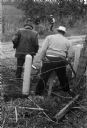
| Date: | 1969 |
|---|---|
| Description: | Five men surveying land across a road. They're standing near a barbed wire fence. |
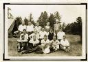
| Date: | 1932 |
|---|---|
| Description: | Group portrait of a group of Wisconsin Land Economic Inventory workers. John Bordner is in the center of the top row. Stanta Bordner is beside him. Uppe... |
| Date: | 1937 |
|---|---|
| Description: | Probably Native Americans receiving instructions on compass use for Wisconsin Land Economic Inventory. |
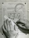
| Date: | |
|---|---|
| Description: | Person's hands, one with with wedding ring on left hand, using a ruler, pencil, and protractor to draw a land cover map for Wisconsin Land Economic Invento... |
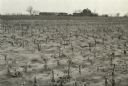
| Date: | 04 23 1937 |
|---|---|
| Description: | Sand barrens being used for poor crops. Note on back of print reads: "This should be in timber." |

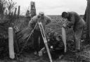
| Date: | |
|---|---|
| Description: | Wisconsin Land Economic Inventory mapping crew starting out in the snow for instruction. |

| Date: | 04 1937 |
|---|---|
| Description: | From back of print: "Dane County, Town of Middleton, north 1/2 section of section 17 looking SW from a hill across the valley showing erosion and stump pas... |
| Date: | |
|---|---|
| Description: | Series 698, General Land Office Survey Plats, vol. 1. |

| Date: | |
|---|---|
| Description: | This map surveyed under the direction of Capt. Thomas J. Cram is one in a series of seven. The map shows part of the Fox River and the beginning of the tow... |

| Date: | 1840 |
|---|---|
| Description: | This map surveyed under the direction of Captain Thomas J. Cram is one in a series of seventeen that accompanied Cram's report on the Fox-Wisconsin river s... |

| Date: | 1840 |
|---|---|
| Description: | This map surveyed under the direction of Captain Thomas J. Cram is one in a series of seventeen that accompanied Cram's report on the Fox-Wisconsin river s... |

| Date: | 1876 |
|---|---|
| Description: | Made from U.S. Surveys and from minutes furnished by Jos. S. Buck and Dr. C. Chase. Scale 20 CHs to an inch. |
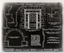
| Date: | 1934 |
|---|---|
| Description: | A blueprint of a survey done of the Michael Brisbois House. |

| Date: | 1874 |
|---|---|
| Description: | Map of New Diggings — inset map in bottom right corner of "Benton & New Diggings" map, on page 11 of "Atlas of Lafayette County Wisconsin," a collect... |

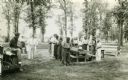
| Date: | 1911 |
|---|---|
| Description: | Workers erecting a steam driven pile driver while others survey for the railroad extension from the village of Prairie du Sac to the dam site on the Wiscon... |
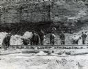
| Date: | 1945 |
|---|---|
| Description: | A group of men laying rails at Hawkins Mine while a man in the background is using surveying equipment near the base of a cliff face. |
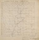
| Date: | |
|---|---|
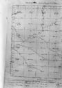
| Description: | Map, "Township No. 22 North, of Range No. 5 West of (?)," surveyed in 1846 and 1853. |
| Date: | 03 16 1950 |
|---|---|
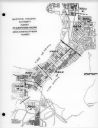
| Description: | Map of areas surveyed by block number as part of the Madison Housing Authority Survey of Substandard Housing. |
If you didn't find the material you searched for, our Library Reference Staff can help.
Call our reference desk at 608-264-6535 or email us at: