Filter: Subject of Aids to navigation
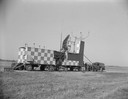
| Date: | |
|---|---|
| Description: | Radar equipment at Truax Field, formerly Madison Municipal Airport. |

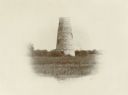
| Date: | 1890 |
|---|---|
| Description: | Second Long Tail Point lighthouse, built in 1859. |
| Date: | |
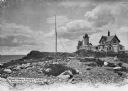
|---|---|
| Description: | Eastern Point Lighthouse at "Mother Ann" and residence on rocky point, Gloucester, Massachusetts. Mother Ann is a rocky cliff at the far south end of Easte... |

| Date: | 05 17 1945 |
|---|---|
| Description: | Martha Akin from Phoenix, Arizona, Audrey Waldschmidt, Bismarck, North Dakota, and Helen Harger, Pontiac, Michigan, are shown plotting a course for a fligh... |

| Date: | 1872 |
|---|---|
| Description: | Map of the Chippewa River, from the head of navigation at the city of Chippewa Falls, covering a distance of 16 miles above : showing the established impro... |
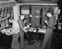
| Date: | 01 30 1947 |
|---|---|
| Description: | Three men working at the Civil Aeronautics Administration interstate communication station at Truax Field. From left to right are: Guy J. Blakely checking... |
| Date: | |
|---|---|
| Description: | La Pointe Light on Long Island (Apostle Islands), Chequamegon Bay, Lake Superior. |
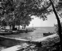
| Date: | 07 22 1949 |
|---|---|
| Description: | Tenney Park breakwater and Lake Mendota. The city of Madison was able to resume construction at no cost. The construction company tearing up East Washingto... |
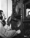
| Date: | |
|---|---|
| Description: | Man wearing microphone and headphones seated before a radar screen. |

| Date: | |
|---|---|
| Description: | A patrol officer looks at his compass as he smokes a cigarette. |

| Date: | 07 1942 |
|---|---|
| Description: | A patrol officer from the 14th Infantry, based in Fort Davis, Panama, follows his compass through the jungle. The patrol officer has a small cigarette in o... |

| Date: | 1950 |
|---|---|
| Description: | A map from the Wisconsin identifying the locations airports and other landing facilities in the state. On the opposite side the map includes an alphabetica... |

| Date: | 1907 |
|---|---|
| Description: | A map of the eastern portion of the Apostle Islands group, and a detailed map of Gull Island showing the relief on the island, are included here, along wit... |

| Date: | 1910 |
|---|---|
| Description: | Chart of Lake Michigan noting soundings near shore and across the lake between harbors. Also included are portions of Wisconsin, Michigan, Illinois, Indian... |

| Date: | 1871 |
|---|---|
| Description: | Asaph Whittlesey arrived in Ashland in 1854, one of the earliest of the settlers who hoped the area would grow and make their fortunes. He drew this map of... |
| Date: | 1913 |
|---|---|
| Description: | Hand-colored postcard showing the lighthouse and fog signal at Devil's Island in the Apostle Islands. Caption reads: "Apostle Islands, Wis. Devil's Island,... |
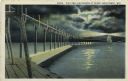
| Date: | 1927 |
|---|---|
| Description: | Hand-colored postcard view of a pier and lighthouse at night. The moon shines through clouds, and light shines in two directions from the beacon on top of ... |

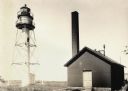
| Date: | 1890 |
|---|---|
| Description: | View from the shore of Kenosha's North Pier and lighthouse. Waves are breaking on the shore of Lake Michigan. |
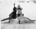
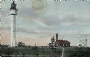
| Date: | |
|---|---|
| Description: | Three men pose standing on ice around North Pier lighthouse. In the background is the town along the shoreline. |
If you didn't find the material you searched for, our Library Reference Staff can help.
Call our reference desk at 608-264-6535 or email us at: