 Filter: Subject of Maps

| We have over 200 original bird's-eye-view maps of Wisconsin cities and villages dating from the 1860s to the early 1900s. |
| See original maps from this Depression-era project that documented Wisconsin's land resources between 1929 and 1949. |
| These maps identify local landowners within each Wisconsin county and provide information about cultural and topographical features. |
| Digitally Reproduced Maps of Wisconsin and American History |
|---|
| Features hundreds of digitally reproduced maps from rare books, manuscripts, magazines and journals covering all aspects of Wisconsin and American History. |
| Exquisite examples of significant maps related to New France and French Great Lakes exploration, early maps of Florida and Mexico, later maps of Wisconsin. |
| Access approximately 200 modern maps of basic cultural and geographical data about Wisconsin and its history. Perfect for teachers, students. |
| Original, meticulously detailed street-level maps for 325 Wisconsin communities, 1883-1930, originally used to determine a property's fire hazard. |
| U.S. General Land Office Surveyors' Field Notes and Plat Maps |
|---|
| Hand-drawn township plat maps and surveyors field notes about tree cover, soils, streams, rock outcroppings, villages, trails and roads from 1833-1866. |
| Explore our physical and digital collections of more than 25,000 maps and atlases, which focus on Wisconsin, the Midwest, the U.S. and Canada. |
| Throughout history maps have been a mix of both art and science, using pictures to represent fact, estimation and even humor. |
| Combine geography and map skills with reading, math, and problem-solving in this lesson plan |
| Using historic and current maps, students will identify change over time in Wisconsin communities in this lesson |
| Introduce students to basic map orientation skills using their own community |
| Wisconsin in the Civil War: Camp Randall |
|---|
| In this lesson students will examine the letter of John Cronk to learn more about Camp Randall and the role Wisconsin played in the Civil War |
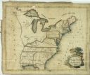
| Date: | 1809 |
|---|---|
| Description: | Embroidered sampler of a map of the United States. |
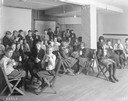
| Date: | 1921 |
|---|---|
| Description: | Classroom full of school children drinking milk at Washington school. |

| Date: | 1907 |
|---|---|
| Description: | Illustration from an International Harvester McCormick line catalog showing the McCormick name in script superimposed over a globe of the earth. |
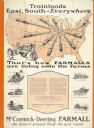
| Date: | 1928 |
|---|---|
| Description: | Advertising poster for McCormick-Deering Farmall tractors showing a map of the United States with trains speeding in all directions from Illinois. Bears th... |

| Date: | 1900 |
|---|---|
| Description: | Print advertisement for the McCormick Harvesting Machine Company showing a giant Lion with its claws on a globe of the earth. The earth bears the words "Wo... |

| Date: | 07 1838 |
|---|---|
| Description: | A map diagram of Indian effigy mounds seven miles east of Blue Mounds in the Wisconsin Territory. |
If you didn't find the material you searched for, our Library Reference Staff can help.
Call our reference desk at 608-264-6535 or email us at: