Map of the City of La Crosse, Wisconsin | Map or Atlas | Wisconsin Historical Society

Map or Atlas

Map of the City of La Crosse, Wisconsin

Map of the City of La Crosse, Wisconsin | Map or Atlas | Wisconsin Historical Society
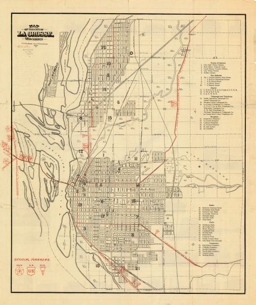
This map includes an index and highways marked in red. Attractions on the map include: Four Mile House, Cold Springs, Grand Crossing Station, Coleman Slough, French Slough, Copeland Park, Freight depot, Jolynn Slough, Taylors Island, Bates Island, Pettibone Park, Isle La Plume, Isle a Plume Slough, City Water Works, Oak Grove Cemetery, Hixon Reserve, Golf Links, Inter State Fair Grounds, Riverside Park, Market Square, Court House Square, Burns Park, Cameron Park, High School, Catholic Cemetery, Hogan School, West Avenue Play Field, Fire Stations, Railroad depots, North American Telegraph Company, Postal Telegraph Company, Western Union Telegraph Company, La Crosse Telephone Company Station, AT&T Company, Wisconsin Telephone Company, Northwestern Bell Telephone Company, Tri State Telephone and Telegraph Company, La Crosse Inter Urban Telephone Company, Grandview Hospital, La Crosse Hospital, Lutheran Hospital, Saint Francis Hospital, Saint Ann Annex, Saint Camillus, Batavian National Bank, Exchange State Bank, Gateway City Bank, La Crosse Trust Company, National Bank, Security Bank, State Bank, Myrick Park, Forest Avenue Park, Jewish Cemetery, North Side Cemetery, Community House, Tourist Camp, Bathing Beach, Vocational School, Municipal Bath House, United States Weather Bureau, State Normal School and Physical Education Building, Fish Hatchery, Logan Junior High School, High School Manual Training, City Hall, YMCA, Public Library, Chamber of Commerce, Court House, Play Grounds, Post Office, La Crosse River old and new channels. The map is dated 1926; but the date on the title panel is 1927. The back of the map includes a sketch of the Mississippi River valley and other text and illustrations.
DESCRIPTION
This map includes an index and highways marked in red. Attractions on the map include: Four Mile House, Cold Springs, Grand Crossing Station, Coleman Slough, French Slough, Copeland Park, Freight depot, Jolynn Slough, Taylors Island, Bates Island, Pettibone Park, Isle La Plume, Isle a Plume Slough, City Water Works, Oak Grove Cemetery, Hixon Reserve, Golf Links, Inter State Fair Grounds, Riverside Park, Market Square, Court House Square, Burns Park, Cameron Park, High School, Catholic Cemetery, Hogan School, West Avenue Play Field, Fire Stations, Railroad depots, North American Telegraph Company, Postal Telegraph Company, Western Union Telegraph Company, La Crosse Telephone Company Station, AT&T Company, Wisconsin Telephone Company, Northwestern Bell Telephone Company, Tri State Telephone and Telegraph Company, La Crosse Inter Urban Telephone Company, Grandview Hospital, La Crosse Hospital, Lutheran Hospital, Saint Francis Hospital, Saint Ann Annex, Saint Camillus, Batavian National Bank, Exchange State Bank, Gateway City Bank, La Crosse Trust Company, National Bank, Security Bank, State Bank, Myrick Park, Forest Avenue Park, Jewish Cemetery, North Side Cemetery, Community House, Tourist Camp, Bathing Beach, Vocational School, Municipal Bath House, United States Weather Bureau, State Normal School and Physical Education Building, Fish Hatchery, Logan Junior High School, High School Manual Training, City Hall, YMCA, Public Library, Chamber of Commerce, Court House, Play Grounds, Post Office, La Crosse River old and new channels. The map is dated 1926; but the date on the title panel is 1927. The back of the map includes a sketch of the Mississippi River valley and other text and illustrations.
RECORD DETAILS
Image ID:105889
Creation Date: 1927
Creator Name:La Crosse Chamber of Commerce
City:La Crosse
County:La Crosse
State:Wisconsin
Collection Name:Map Collection
Genre:Map or Atlas
Original Format Type:prints, photomechanical
Original Format Number:GX9029 L14 1927 L
Original Dimensions:60 x 53 cm., on sheet 66 x 56 cm.
ADDITIONAL INFORMATION
To view the entire image see Maps and Atlases in Our Collections.
SUBJECTS
Railroad stations
Railroads
Streets
Mississippi River
Telephone companies
Fish hatcheries
Church buildings
Library buildings
Banks and banking
Schools
Cemeteries
Cities and towns
Parks
Postal service

How to Purchase a Copy

Buy The Image

For commercial or non-profit use, please contact Image Sales.

By clicking "BUY" you agree to our Terms of Use.

10-percent discount for Society Members.

Image-purchasing questions? Please Contact Us.

RIGHTS AND PERMISSIONS
This image is issued by the Wisconsin Historical Society. Use of the image requires written permission from the staff of the Collections Division. It may not be sold or redistributed, copied or distributed as a photograph, electronic file, or any other media. The image should not be significantly altered through conventional or electronic means. Images altered beyond standard cropping and resizing require further negotiation with a staff member. The user is responsible for all issues of copyright. Please Credit: Wisconsin Historical Society.
Reference Details
Location:Wisconsin Historical Society Archives, 4th Floor, Madison, Wisconsin

How to View in Person

To view this image, visit the Archives Research Room on the 4th floor at the Society Headquarters building in Madison, WI. Print out this index page and present it to the librarian. Use the links below to plan your visit to the Society's Archives.

Checking Out Materials

Visual materials in the Archives do not circulate and must be viewed in the Society's Archives Research Room.

How to Cite

For the purposes of a bibliography entry or footnote, follow this model:

Wisconsin Historical Society Citation
Wisconsin Historical Society, Creator, Title, Image ID. Viewed online at (copy and paste image page link).
Wisconsin Center for Film and Theater Research Citation
Wisconsin Center for Film and Theater Research, Creator, Title, Image ID. Viewed online at (copy and paste image page link).

Have Questions?

Contact our Archives staff by email.