| Explore our Visual Materials collection of nearly 3 million images in more than 6,000 collections. Over 80,000 images are available online. |
| Learn about the wide range of visual materials subjects available to view both online and in our Archives |
| Photographs and Poetic Texts |
|---|
| Explore this online image collection from one of the country's most respected scholars in the field of photography and archives. |
| Information on over 7,000 photographers who were active in Wisconsin from about 1840 to 1976. |
| Common questions about purchasing historical images from the Wisconsin Historical Society. |
| Defining Permission, Copyright and Terms of Use |
|---|
| Learn about obtaining permission and the copyright laws that apply to images purchased from the Wisconsin Historical Society. |
| Learn how to purchase digital files and prints and receive permission for commercial and non-profit projects. |
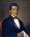
| Date: | 1858 |
|---|---|
| Description: | Sixth plate ferrotype/tintype portrait of Lyman Draper (1815-1891), an American historical collector and librarian. |
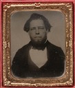
| Date: | |
|---|---|
| Description: | Studio portrait in front of a painted backdrop of the three Pond brothers, George F., James B., and Homer. They all have beards and moustaches. Two of the ... |
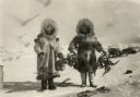
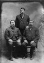
| Date: | 1930 |
|---|---|
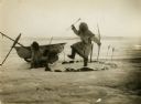
| Description: | Wenga and Amutuk catching crabs in the Arctic. |
| Date: | 1930 |
|---|---|
| Description: | Eskimo duck dance to celebrate the spring hunt. |
| Date: | 1924 |
|---|---|
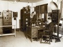
| Description: | Interior of WMAQ Radio Station with Chief Engineer Donald Weller standing. |
| Date: | 1900 |
|---|---|
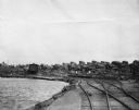
| Description: | Star Lake, Arbor Vitae Township, with the railroad tracks of Chicago, Milwaukee and St. Paul Railway on right and lake on the left. |
| Date: | 11 25 1871 |
|---|---|
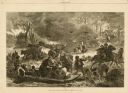
| Description: | Engraved view of Peshtigo Fire showing people trying to escape the flames by boat and on horseback. A team of cattle also seek refuge and several birds tak... |
| Date: | 1960 |
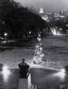
|---|---|
| Description: | Elevated view looking east from Lincoln Terrace on Bascom Hill on the University of Wisconsin-Madison campus. The Lincoln Monument is in the foreground and... |
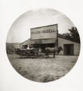
| Date: | 05 26 1894 |
|---|---|
| Description: | Exterior view of the Wilson Riddell general store, with a horse-drawn wagon parked in front. There is a post office and paint shop attached to the store. S... |
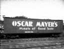
| Date: | 08 04 1931 |
|---|---|
| Description: | Oscar Mayer refrigerated railroad freight car with "Oscar Mayer's Meats of Good Taste" advertisement on the side. |
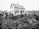
| Date: | 09 04 1895 |
|---|---|
| Description: | Julius Koehler family in their garden in front of their newly built frame home. The original Koehler farm was destroyed by forest fire in July of 1894, evi... |
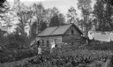
| Date: | 09 09 1895 |
|---|---|
| Description: | Log cabin of N.G. Willard on 80 acres of land. Two women, a young child, and an infant are posing outdoors in the yard. Laundry is hanging on lines on the ... |
If you didn't find the material you searched for, our Library Reference Staff can help.
Call our reference desk at 608-264-6535 or email us at: