Map or Atlas
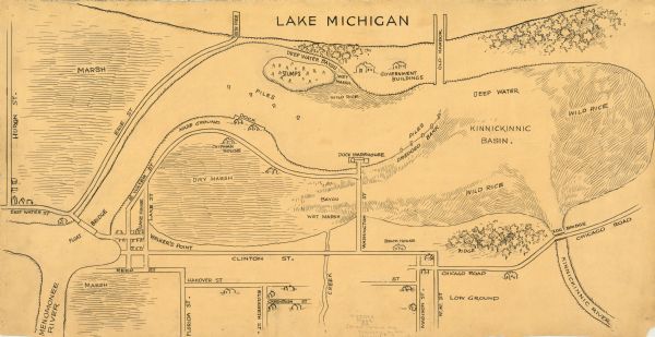
My Recollections of Jones Island and Vicinity

| Pen-and-ink on paper. The title of the map is inscribed on the back. The map shows buildings, roads, marshes, wild rice, piles and docks, deep water, and old harbor. Roads running vertically begin with "Huron St." and end with "Washington St." Roads running horizontally begin with "East Water St." and end with "Chicago Road." |
| Image ID: | 99156 |
|---|---|
| Creation Date: | circa 1848 |
| Creator Name: | Chipman, D. W. |
| City: | Milwaukee |
| County: | Milwaukee |
| State: | Wisconsin |
| Collection Name: | Map Collection |
| Genre: | Map or Atlas |
| Original Format Type: | drawings |
| Original Format Number: | GX9029 M663 CA |
| Original Dimensions: | 30 x 58 cm. |
| Islands |
| Rice |
| Marshes |
| Harbors |
| Roads |
| Streets |
| Land |
| This image is issued by the Wisconsin Historical Society. Use of the image requires written permission from the staff of the Collections Division. It may not be sold or redistributed, copied or distributed as a photograph, electronic file, or any other media. The image should not be significantly altered through conventional or electronic means. Images altered beyond standard cropping and resizing require further negotiation with a staff member. The user is responsible for all issues of copyright. Please Credit: Wisconsin Historical Society. |
| Location: | Wisconsin Historical Society Archives, 4th Floor, Madison, Wisconsin |
|---|
