 Filter: Categories of Wisconsin Historical Images
Filter: COLLECTION_NAME of Parker Maps
Filter: Subject of landforms
Filter: Categories of Wisconsin Historical Images
Filter: COLLECTION_NAME of Parker Maps
Filter: Subject of landforms
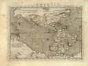
| Date: | 1576 |
|---|---|
| Description: | Map of America. This is the oldest map in the Parker collection. It is based on the geography of Ortelius, who is considered to be the creator of the first... |

| Date: | 1698 |
|---|---|
| Description: | Copperplate engraving. Scale [ca. 1:11,500,00]. |

| Date: | 1755 |
|---|---|
| Description: | Hand-colored. Paris: 1755. Scale [ca. 1:3,000,000]. |
If you didn't find the material you searched for, our Library Reference Staff can help.
Call our reference desk at 608-264-6535 or email us at:
