 Filter: Categories of Wisconsin Historical Images
Filter: Creator Name of Dahl, Ole Rasmussen, 1817-1882
Filter: Year of 1800-1899
Filter: Categories of Wisconsin Historical Images
Filter: Creator Name of Dahl, Ole Rasmussen, 1817-1882
Filter: Year of 1800-1899
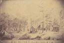
| Date: | 1862 |
|---|---|
| Description: | Sketch of the camp of the 15th Regiment of the Wisconsin Volunteer Infantry on Island No. 10 during the Civil War. Colonel Hans Christian Heg commanded the... |
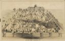
| Date: | 1865 |
|---|---|
| Description: | Detail (central image) of "The Southern Prisons of U.S. Officers" showing Camp Asylum in South Carolina. |

| Date: | 12 26 1862 |
|---|---|
| Description: | Handsketched map of the area around Knobs Gap. |
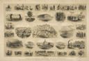
| Date: | 1865 |
|---|---|
| Description: | "The Southern Prisons of U.S. Officers: Scenes from life as a prisoner of war, with explanations--sketched by Lieut. & Top Eng'r O.R. Dahl, 15th Wisconsin ... |

| Date: | 1863 |
|---|---|
| Description: | This map is a hand-colored, pen and ink, drawing by Ole R. Dahl of Co. B, 15 Wisconsin Infantry shows the battlefield at Stones River, depicting roads, str... |

| Date: | 1880 |
|---|---|
| Description: | A hand-colored map of the Chippewa, Price, Taylor and the northern part of Clark counties, which shows the locations of farmhouses, schoolhouses, churches,... |
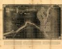
| Date: | 1881 |
|---|---|
| Description: | This map of Chippewa Falls is a proposal of river improvements using booming and rafting facilities and shows the city of Chippewa Falls, the Chippewa Rive... |
If you didn't find the material you searched for, our Library Reference Staff can help.
Call our reference desk at 608-264-6535 or email us at: