Filter: Categories of Wisconsin Historical Images
Filter: Community of Cedarburg
Filter: Subject of architecture
Filter: Categories of Wisconsin Historical Images
Filter: Community of Cedarburg
Filter: Subject of architecture

| Date: | 1882 |
|---|---|
| Description: | This map of Cedarburg is a bird's-eye map with an inset of Cedarburg Brewery. Relief is shown pictorially and the map includes an index to buildings. |
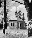
| Date: | 1907 |
|---|---|
| Description: | View down center of unpaved street in Cedarburg, with a large church at the far end. |
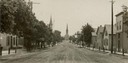
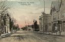
| Date: | 1907 |
|---|---|
| Description: | View across Washington Avenue. A man is standing in the street near the curb. Caption reads: "Cedarburg, Wis., Washington Avenue looking North." |
| Date: | 1966 |
|---|---|
| Description: | Button factory at the Wetzel residence. At one time, bone buttons were manufactured in this building. A cat and a hand pump are in the foreground. |

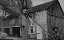
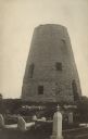
| Date: | 1872 |
|---|---|
| Description: | Wind powered stone grist mill. Two men stand on a wood balcony near the open doorway of the windmill. |
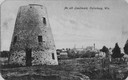
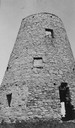
| Date: | 1910 |
|---|---|
| Description: | View of the stone building, with a town in the distance. Caption reads: "An old Landmark, Cedarburg, Wis." |
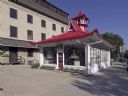
| Date: | 2008 |
|---|---|
| Description: | Alexander C. Eschweiler, a well-known architect in Milwaukee, designed this exotic station for the Wadhams Oil and Grease Company of Milwaukee in 1926. |
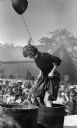
| Date: | 09 15 1984 |
|---|---|
| Description: | Patricia Mallach of Waukesha demonstrating grape stomping to a crowd of onlookers during the Wine and Harvest Festival. She has a balloon tied around her n... |
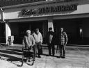
| Date: | 11 30 2007 |
|---|---|
| Description: | "This is Rich's Restaurant at W63 N144 Washington Ave in Cedarburg." From left to right; Shirley Widmer, John Bodden, Carl Bernhard, and Ralph "Buddy" Ruec... |

| Date: | 1967 |
|---|---|
| Description: | This map of Cedarburg includes a list of historic buildings in the left margin. The map was created by the Ozaukee County Historical Society for Cedarburg'... |
| Date: | 1915 |
|---|---|
| Description: | Photographic postcard view of the old grist mill, with a cemetery in the foreground. Caption reads: "The Old Mill, Cedarburg." |

| Date: | |
|---|---|
| Description: | Hand-colored bird's-eye view down the center of a main street in Cedarburg. Horse and buggy traffic is in the street, with dwellings and buildings on the l... |

| Date: | |
|---|---|
| Description: | Hand-colored elevated view of a residential neighborhood in Cedarburg. There is a church in the background on the left. Caption reads: "Birds [sic] Eye Vie... |
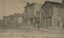
| Date: | |
|---|---|
| Description: | Hand-colored view down center of Washington Avenue, facing south, towards a church building on the horizon. The street is lined with sidewalks, buildings a... |

| Date: | 1915 |
|---|---|
| Description: | Photographic postcard view down unpaved Washington Avenue. A clock on the sidewalk on the left is in front of a musical instrument shop. Snow is on the gro... |

| Date: | |
|---|---|
| Description: | Photographic postcard view across intersection towards Portland Place, a five-story stone building. There are pedestrians on the sidewalks on the left and ... |

| Date: | |
|---|---|
| Description: | Photographic postcard view of Turn Halle, a three-story stone building. Caption reads: "Turn Halle, Cedarburg, Wis." |

| Date: | |
|---|---|
| Description: | Elevated view of Cedar Creek with a tree growing in the middle of it. There are buildings in the background. Caption reads: "Cedar Creek, Cedarburg, Wis." |
If you didn't find the material you searched for, our Library Reference Staff can help.
Call our reference desk at 608-264-6535 or email us at: