 Filter: Categories of Wisconsin Historical Images
Filter: Community of Darlington
Filter: Year of 1800-1899
Filter: Categories of Wisconsin Historical Images
Filter: Community of Darlington
Filter: Year of 1800-1899
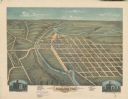
| Date: | 1871 |
|---|---|
| Description: | Darlington, county seat of Lafayette County, was established in the late 1840s, but didn't thrive until the arrival of the railroad in 1856. This view show... |

| Date: | 1881 |
|---|---|
| Description: | Darlington's first settlers arrived by 1826, attracted by the lead mines of the area. Arrival of the railroad in 1856 stimulated growth, and in 1857 the co... |

| Date: | 1896 |
|---|---|
| Description: | Bird's-eye map of Darlington. Area bordered by Washington and North Streets, upper left hand corner, the fairgrounds, upper right corner, River Street, bot... |

| Date: | 1850 |
|---|---|
| Description: | Ink on paper. Shows local streets and Pekatonika River. "John M. Keep, proprietor. "Original plat of Darlington as surveyed by Richardson on June 14, 1850.... |

| Date: | 1855 |
|---|---|
| Description: | This map is ink, pen, and watercolor on paper and shows plat of the town, local streets, lots by number, U.S. subdivisions in red lines, Mineral Point Rail... |
If you didn't find the material you searched for, our Library Reference Staff can help.
Call our reference desk at 608-264-6535 or email us at: