Filter: Categories of Wisconsin Historical Images
Filter: County of Fond du Lac
Filter: Type of Map or Atlas
Filter: Categories of Wisconsin Historical Images
Filter: County of Fond du Lac
Filter: Type of Map or Atlas

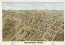
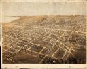
| Date: | 1867 |
|---|---|
| Description: | Birds eye drawing of Fond du Lac depicts street names and street layouts, houses, buildings, trees, and the Fond du Lac River. A reference key at the botto... |

| Date: | 1867 |
|---|---|
| Description: | Bird's-eye map of Ripon, with insets of points of interest. |

| Date: | 1885 |
|---|---|
| Description: | Bird's-eye map of Waupun on the Rock River. There is an inset at top center of "Althouse, Wheeler & Co., Windmills and Pumps." |

| Date: | 1896 |
|---|---|
| Description: | Bird's-eye map of Fond du Lac, looking north west, with two insets of the P.H. Stamm residence, and the Proposed Lakeside Park. thirty-five locations ident... |

| Date: | 1861 |
|---|---|
| Description: | Bird's-eye map of Fond du Lac, "drawn after nature," with a parade of soldiers marching down the street. |

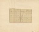
| Date: | 1857 |
|---|---|
| Description: | A quarter section of a map of the city of Fond du Lac. This section features an illustration of Amory Hall and the Exchange Bank of Darling & Co. |

| Date: | 1857 |
|---|---|
| Description: | A quarter section of a map of the City of Fond du Lac featuring the Empire Branch Plank Road. |

| Date: | 1857 |
|---|---|
| Description: | Quarter section of a map of the city of Fond du Lac featuring the Waupun Plank Road. |

| Date: | 1857 |
|---|---|
| Description: | Quarter section of a map of the city of Fond du Lac featuring an illustration of the Lewis House. |

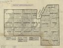
| Date: | 1862 |
|---|---|
| Description: | This map shows townships and sections, landownership and acreages, roads, railroads, cemeteries, churches, schools, mills, and stone quarries. "Engraved, p... |

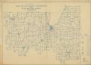
| Date: | 1904 |
|---|---|
| Description: | Map shows townships and sections, landownership and acreages, roads and railroads, and selected buildings. "1904" inscribed on map in pen. Includes busines... |
| Date: | |
|---|---|
| Description: | Map shows rivers and acreages in part of Fond du Lac township and Fond du Lac, Wisconsin. |
| Date: | 1930 |
|---|---|
| Description: | Map shows prairie, oak, maple, oak and maple, marsh conifer, maple and beech, and grass and sedge. |
| Date: | 1911 |
|---|---|
| Description: | Shows roads, railroads, post offices, schools, houses, churches, routes, and collection boxes. Includes distant chart and explanation. "Price 35 cents"--... |

| Date: | 1840 |
|---|---|
| Description: | Shows plat of town, local streets, Fond du Lac River, and part of Lake Winnebago. |
| Date: | 1867 |
|---|---|
| Description: | Bird’s-eye view map. Indexed for points of interest. |

| Date: | 1874 |
|---|---|
| Description: | Includes index to key buildings. Shows local streets, railroads, fairgrounds, mills, schools, churches, and part of Lake Winnebago. Streets running west to... |

| Date: | 1916 |
|---|---|
| Description: | Includes index to businesses, churches, and schools. Shows local streets, buildings, railroads, ward divisions, Fond du Lac River, and part of Lake Winneba... |

| Date: | 1956 |
|---|---|
| Description: | Includes street index. Shows local streets, parks, highways, railroads, Fond du Lac River, and part of lake Winnebago. Also includes text on points of inte... |
If you didn't find the material you searched for, our Library Reference Staff can help.
Call our reference desk at 608-264-6535 or email us at: