 Filter: Categories of Wisconsin Historical Images
Filter: County of Polk
Filter: Categories of Wisconsin Historical Images
Filter: County of Polk

| Date: | 1914 |
|---|---|
| Description: | Map shows townships, schools, creameries, post offices, and roads. The left side of the map features a legend with symbols for points of interest. |

| Date: | 1871 |
|---|---|
| Description: | Map created between 1871 and 1880. Shows townships, post offices, a possible railroad to Penoka Iron Range, and the North Wisconsin Railroad. |

| Date: | 1890 |
|---|---|
| Description: | Map shows St. Croix, Wisconsin and a small portion of Taylor's Falls, Minnesota. Map reads: "The Lands shaded show the Mill & Riparian Reservation & unplat... |

| Date: | 1969 |
|---|---|
| Description: | Map showing St. Croix Falls and Taylors Falls, Minnesota. The map was produced by the St. Croix Falls Chamber of Commerce and Taylor Falls Commercial Club.... |

| Date: | |
|---|---|
| Description: | Photographic postcard view of the exterior of the Court House. A large belfry is above the arched entrance way. |

| Date: | 1943 |
|---|---|
| Description: | Photographic postcard view of a log cabin in the woods. Caption reads: "Log Cabin, Dixie Lodge, Balsam Lake, Wis." |
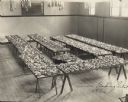
| Date: | 1926 |
|---|---|
| Description: | Entries in the Lewis Baking Contest. Seven tables full of plates of desserts are displayed in a large room. |

| Date: | 1936 |
|---|---|
| Description: | Picnic area at Interstate Park showing parked automobiles and visitors. |
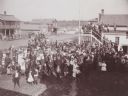
| Date: | 1900 |
|---|---|
| Description: | Elevated view of crowd of men, women and children, gathered for some unidentified occasion, standing in the street. There is also a group of people gathere... |
| Date: | 1910 |
|---|---|
| Description: | Colorized postcard view down hill toward the lake. Caption reads: "South Clear Lake, Wis." |

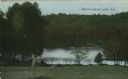
| Date: | 1910 |
|---|---|
| Description: | Elevated black and white photographic postcard of Lake Cemelia, with boathouse and pier. |

| Date: | 1874 |
|---|---|
| Description: | This map shows townships and sections, post offices, roads, and railroads. The left margin reads: "For sale at Cushing Land Agency, St. Croix Falls, Wis. 4... |

| Date: | 1960 |
|---|---|
| Description: | This blue line print map shows pipes, valves, well site, and elevation tank, as well as lot and block numbers and dimensions. The map includes inset of con... |
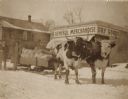
| Date: | |
|---|---|
| Description: | Team of oxen pulling a sled loaded with large sacks on a snowy street in front of a General Merchandise Dry Goods store. Two men stand at the back of the s... |
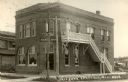
| Date: | |
|---|---|
| Description: | Exterior view from street of the State Bank with a corner entrance. The brick building has two-stories, with a set of wooden stairs on one side leading up ... |
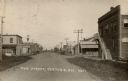
| Date: | 1920 |
|---|---|
| Description: | View down center of Main Street. The State Bank is in the foreground on the right. A hardware store and hotel are on the left. There is a windmill in the d... |
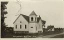
| Date: | |
|---|---|
| Description: | Exterior view from road towards the M.E. Church, a white wooden building with a bell tower. Caption reads: "M.E. Church, Centuria, Wis." |
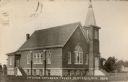
| Date: | |
|---|---|
| Description: | Exterior view of the Swedish Lutheran Church, a brick building with a bell tower and steeple. Stained-glass windows are on the front and sides. Caption rea... |
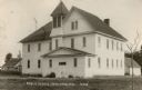
| Date: | 1920 |
|---|---|
| Description: | Exterior view of the public school, which is a two-story wooden building with a bell tower. Caption reads: "Public School, Centuria, Wis." |
If you didn't find the material you searched for, our Library Reference Staff can help.
Call our reference desk at 608-264-6535 or email us at:
