 Filter: Categories of Wisconsin Historical Images
Filter: FORMAT_TYPE of prints, photomechanical
Filter: Year of 1600-1699
Filter: Categories of Wisconsin Historical Images
Filter: FORMAT_TYPE of prints, photomechanical
Filter: Year of 1600-1699

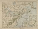
| Date: | 1632 |
|---|---|
| Description: | The Wisconsin portion of Champlain's 1632 map, augmented since the previous one, for navigation according to the true Meridien, by Sieur de Champlain. The ... |

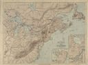
| Date: | 1670 |
|---|---|
| Description: | This map is in French and shows Lac Tracy ov Superieur (Lake Superior), Baye des Puans (Green Bay), and portions of Lac des Ilinois (Lake Michigan) and Lac... |

| Date: | 1673 |
|---|---|
| Description: | P. Marquette en Joliet, gedan in't jaar 1673. |

| Date: | 1673 |
|---|---|
| Description: | Facsimile of the autograph map of the Mississippi or Conception River drawn by Father Marquette at the time of his voyage. From the original preserved at S... |
| Date: | 1610 |
|---|---|
| Description: | A map of New France, including parts of the United States and Canada, to illustrate the Jesuit relations and allied documents. There is some handwriting an... |
| Date: | 1610 |
|---|---|
| Description: | A map of New France, including parts of the United States and Canada, to illustrate the Jesuit relations and allied documents. |

| Date: | 1612 |
|---|---|
| Description: | Map of New France, the area that is now eastern Canada and north eastern United States, showing lakes, rivers, and landforms. The locations of several Nati... |

| Date: | 1609 |
|---|---|
| Description: | Illustration of an elevated view of a battle between Iroquois tribe and French on the banks of river. The Iroquois are unclothed and armed with bows and ar... |

| Date: | 1615 |
|---|---|
| Description: | Illustration of the Huron Indians and French explorers attacking an Iroquois fort near present day Fenner, New York. A wooden platform was constructed to f... |

| Date: | 1608 |
|---|---|
| Description: | Illustraiton, with alphabetical key in French, of the Habitation of Quebec, a conglomeration of connected buildings on the banks of the St. Lawrence River ... |
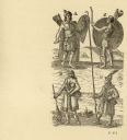
| Date: | 1615 |
|---|---|
| Description: | Drawings of four Native Americans. A and C are dressed for combat. B appears to be a woman carrying and nursing an infant, and D is wearing winter garb, in... |
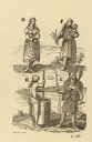
| Date: | 1616 |
|---|---|
| Description: | Illustration of four Algonquian Indians. E depicts a man dressed for combat in wood armor. F shows a woman in her regular dress carrying a child and an ear... |
If you didn't find the material you searched for, our Library Reference Staff can help.
Call our reference desk at 608-264-6535 or email us at:

