 Filter: Categories of Wisconsin Historical Images
Filter: FULL_DATE of 1839
Filter: Subject of intellectual life
Filter: Categories of Wisconsin Historical Images
Filter: FULL_DATE of 1839
Filter: Subject of intellectual life
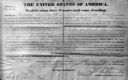
| Date: | 1839 |
|---|---|
| Description: | The deed is for sale of land under jurisdiction of Mineral Point Office in 1839 during the Van Buren administration. Frederick Sprague is from Oakland Coun... |

| Date: | 1839 |
|---|---|
| Description: | This map shows the geological makeup of the valley in red, yellow, and green, the Mississippi River, and the location of Fort Crawford. The geology on the ... |
If you didn't find the material you searched for, our Library Reference Staff can help.
Call our reference desk at 608-264-6535 or email us at:
