Filter: Categories of Wisconsin Historical Images
Filter: FULL_DATE of 1840
Filter: Creator Name of Unknown
Filter: Categories of Wisconsin Historical Images
Filter: FULL_DATE of 1840
Filter: Creator Name of Unknown
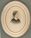
| Date: | 1840 |
|---|---|
| Description: | Head and shoulders portrait, possibly of Jane Fisher Rolette Dousman, wife of Hercules Dousman and mother of H. Louis Dousman. The photograph has been enh... |

| Date: | 1840 |
|---|---|
| Description: | A hand-drawn plat map of Mineral Point, Wisconsin showing street layout and location of buildings. |
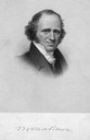
| Date: | 1840 |
|---|---|
| Description: | A head and shoulders portrait of Martin Van Buren, the 8th President of the United States from 1837-1841. Born on December 5, 1782 in Columbia, New York, ... |
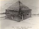
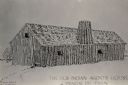
| Date: | 1840 |
|---|---|
| Description: | The first school house at Prairie du Chien, Wisconsin. There is a fence behind the building, and hills in the background. |

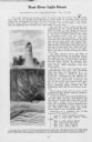
| Date: | 1840 |
|---|---|
| Description: | Fort Crawford (the second site, with buildings of 1829-?), on the east bank of the Mississippi River, about 2 miles above the mouth of the Wisconsin River. |

| Date: | 1840 |
|---|---|
| Description: | A view of Fort Crawford (the second site and buildings of 1829-?). |
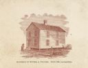
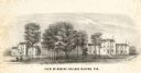
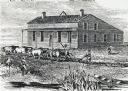
| Date: | 1840 |
|---|---|
| Description: | Home of William Augustus Prentiss, built in 1836 and burned in 1845. Small two-story house. Four people are standing around the house. |
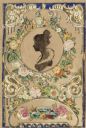
| Date: | 1840 |
|---|---|
| Description: | Valentine's Day card with flowers and gold and white flourishes. Text at bottom reads: "Ever Thine." It has been mounted to a piece of paper and a silhouet... |

| Date: | 1840 |
|---|---|
| Description: | Sixth plate daguerreotype. Waist-up portrait of Elsey Ormsbee Bristol. Elsey was born May 27, 1783; married August 1, 1804 at Warwick, Massachusetts to Cha... |

| Date: | 1840 |
|---|---|
| Description: | Pen-and-ink on paper. Map shows 1840’s homes with owner names, a Native American cemetery, and other points of interest. Relief shown by hachures. Oriented... |

| Date: | 1840 |
|---|---|
| Description: | Shows plat of town, local streets, Fond du Lac River, and part of Lake Winnebago. |

| Date: | 1840 |
|---|---|
| Description: | This is a plat map of Sheboygan showing the Sheboygan River and Lake Michigan. Streets are labeled and plats are numbered in quadrants. Some points of inte... |
| Date: | 1840 |
|---|---|
| Description: | Sod-breaker and five yoke of oxen plowing in front of the “Old Cottage Inn.” In the foreground a boat is on the shoreline. |

| Date: | 1840 |
|---|---|
| Description: | This map of Kewaunee shows lot and block numbers, Lake Michigan, and includes a location map showing proposed railroads. The map includes manuscript annota... |

| Date: | 1840 |
|---|---|
| Description: | This map shows local streets, numbered lots, and part of Blue Mounds Branch. The map reads: "NE 1/4 NW 1/4 Sect. 16 - T5 - R5E." under the title and is dat... |

| Date: | 1840 |
|---|---|
| Description: | This manuscript map is ink, pencil, and watercolor on paper and shows landownership. An approximate date can be established by the names written on the pla... |

| Date: | 1840 |
|---|---|
| Description: | A document written in Norwegian with the words "Otte Skilling Species" at the top of the page. |
If you didn't find the material you searched for, our Library Reference Staff can help.
Call our reference desk at 608-264-6535 or email us at: