Filter: Categories of Wisconsin Historical Images
Filter: FULL_DATE of 1842
Filter: Categories of Wisconsin Historical Images
Filter: FULL_DATE of 1842

| Date: | 1842 |
|---|---|
| Description: | This hand-colored lithograph of the second Fort Howard, with Indians canoeing on the Fox River, shows the hospital built 1834-1835 outside the stockade on ... |
| Date: | 1842 |
|---|---|
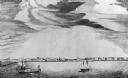
| Description: | A Menominee village as depicted by Francois, Comte de Castelnau, a French naturalist and diplomat who visited the Green Bay area about 1838. The detailed, ... |
| Date: | 1842 |
|---|---|
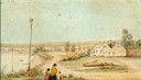
| Description: | Watercolor of the Reid House, residence of William Reid at the head of Big Foot Lake (Lake Geneva). Two children and a woman are in the foreground. |
| Date: | 1842 |
|---|---|
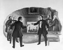
| Description: | Shooting of Charles C.P. Arndt by James Vineyard in the territorial council chamber of the legislature. This depiction of the event was created by the staf... |
| Date: | 1842 |
|---|---|
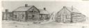
| Description: | Drawing of Front and State Streets, showing the first houses in La Crosse. |
| Date: | 1842 |
|---|---|
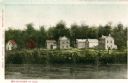
| Description: | View across the river towards several residences on the opposite shoreline. Caption reads: "Watertown in 1842." |

| Date: | 1842 |
|---|---|
| Description: | American Fur Company with both Mission churches. Sketch purportedly by a Native American youth. Probably an overpainted photographic copy enlargement. Pape... |
| Date: | 1842 |
|---|---|
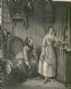
| Description: | An engraving depicting a woman reprimanding a young woman, while a young man looks in at a window in the background. |

| Date: | 1842 |
|---|---|
| Description: | Map reads: "Wisconsin". The map depicts the counties as of 1842 and the various areas of Indian settlements. The scale is twenty miles for every inch. |

| Date: | 1842 |
|---|---|
| Description: | A map of the Western rivers, a "travellers guide" exhibiting the Mississippi, Missouri, Ohio and Illinois Rivers with principal towns. |

| Date: | 1842 |
|---|---|
| Description: | Large volume rare book entitled "United States Exploring Expedition". During the years 1838-1842 and under the command of Charles Wilkes,U.S.N. An Atlas of... |
| Date: | 1842 |
|---|---|
| Description: | Large volume rare book entitled "United States Exploring Expedition". During the years 1838-1842 and under the command of Charles Wilkes, U.S.N. An Atlas o... |

| Date: | 1842 |
|---|---|
| Description: | Large volume rare book entitled "United States Exploring Expedition". During the years 1838-1842 and under the command of Charles Wilkes, U.S.N. An Atlas o... |
| Date: | 1842 |
|---|---|
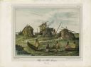
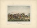
| Description: | Menominee war dance, as depicted by Francois, Comte de Castelnau, a French naturalist and diplomat who visited Green Bay, Wisconsin about 1838. This detail... |

| Date: | 1842 |
|---|---|
| Description: | This map shows portions of northern Illinois and Wisconsin surveyed by the map's creation. It shows county lines and university land, and depicts lead and ... |

| Date: | 1842 |
|---|---|
| Description: | Relief shown by hachures. Shows furnaces, saw mills, houses, roads, grist mills, entries, reservations, and diggings. "Compiled by order of the Board of C... |
| Date: | 1842 |
|---|---|
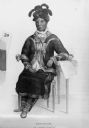
| Description: | Portrait of a woman, who is sitting with her left arm resting on a desk or table. She is wearing a jacket, hat, skirt, and pants. According to History o... |
If you didn't find the material you searched for, our Library Reference Staff can help.
Call our reference desk at 608-264-6535 or email us at: