 Filter: Categories of Wisconsin Historical Images
Filter: FULL_DATE of 1850
Filter: Categories of Wisconsin Historical Images
Filter: FULL_DATE of 1850

| Date: | 1850 |
|---|---|
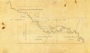
| Description: | This 1850 survey by William H. Canfield shows the mounds near Wiegands Bay on the Wisconsin River in the Town of Merrimac, Sauk County, Wisconsin. |

| Date: | 1850 |
|---|---|
| Description: | Ink on paper. Shows local streets and Pekatonika River. "John M. Keep, proprietor. "Original plat of Darlington as surveyed by Richardson on June 14, 1850.... |

| Date: | 1850 |
|---|---|
| Description: | Map showing Indian mounds and graves as well as ground cover types at Township 8, Range 22. There is an inset diagram of an effigy mound labeled "The Cross... |

| Date: | 1850 |
|---|---|
| Description: | A map which includes the ink and pencil annotations showing the sections, sold parcels of land, and streams and lakes on a printed township base map for To... |

| Date: | 1850 |
|---|---|
| Description: | Map is pen and pencil on paper. The map shows roads, creeks, and the Chequamegon Bay. The map is undated and prepared sometime between the establishment of... |
| Date: | 1850 |
|---|---|
| Description: | The map is ink on tracing cloth. The map shows portions of township 20 north, range 12 east, section 30 (in the Town of Saxeville) and township 20 north, r... |

| Date: | 1850 |
|---|---|
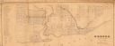
| Description: | This map of Cassville shows plat of town, roads, and the Mississippi River. Relief is shown by hachures. The map includes an inset map of a Plat of townshi... |

| Date: | 1850 |
|---|---|
| Description: | This map of Cassville shows plat of the town, roads, landings and public wharfs and the Mississippi River. |

| Date: | 1850 |
|---|---|
| Description: | This map of the Town of Lake is ink and pencil on paper and shows lots and acreages, reserved land, and public squares. The bottom of the map includes a ke... |

| Date: | 1850 |
|---|---|
| Description: | This map of Geneva shows lots and acreages, reserved land, and public squares. Streets and Lake Geneva are labeled. The map includes manuscript annotations... |
| Date: | 1850 |
|---|---|
| Description: | This map shows a plat of city, land ownership by name, local streets, roads, and part of Willow River and Lake St. Croix. The map is indexed by additions a... |

| Date: | 1850 |
|---|---|
| Description: | This map shows a plat of the town, land owners by name, local streets, railroads, churches, and part of the Rock River. The map is also indexed by church d... |
| Date: | 1850 |
|---|---|
| Description: | Quarter plate daguerreotype of a painting of Bland Ballard (1761-1853). Ballard was a noted Kentucky pioneer, and also served as a scout for General George... |
| Date: | 1850 |
|---|---|
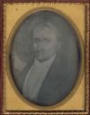
| Description: | Quarter plate daguerreotype of a painting of General George Rogers Clark, as an older man. Clark is most well known for his role in the defense of the Nort... |
| Date: | 1850 |
|---|---|
| Description: | Sixth plate daguerreotype of Captain Joseph Dickson, waist-up, facing front and slightly towards the right. Dickson fought in the Black Hawk War in 1832. |
| Date: | 1850 |
|---|---|
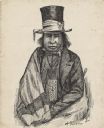
| Description: | Waist-up pen and ink drawing of Chief Oshkosh. He is wearing a top hat wrapped with a ribbon. He wears a suitcoat, bowtie, beaded neckpouch and a blanket w... |
| Date: | 1850 |
|---|---|
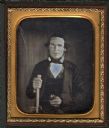
| Description: | A sixth plate daguerreotype of Elijah Swan. The subject is half length, facing front. He is holding a cane in his right hand, and an unidentified object i... |
| Date: | 1850 |
|---|---|
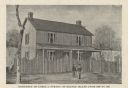
| Description: | Printed postcard of an illustration of the James Strang residence on Beaver Island, Michigan. Two men are standing in front of a stockade fence in front of... |
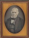
| Date: | 1850 |
|---|---|
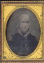
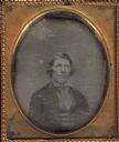
| Description: | Quarter plate daguerreotype of Captain John Gass, (1765-?). The portrait is waist-up, facing front but slightly to the left. He wears a vertically striped ... |
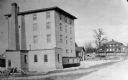
| Date: | 1850 |
|---|---|
| Description: | A grist mill on the Yahara River at the outlet of Lake Mendota. The mill, called Farwell's Madison Mills was built in 1850 by Governor Farwell. The origina... |
If you didn't find the material you searched for, our Library Reference Staff can help.
Call our reference desk at 608-264-6535 or email us at: