 Filter: Categories of Wisconsin Historical Images
Filter: FULL_DATE of 1852
Filter: Type of Map or Atlas
Filter: Categories of Wisconsin Historical Images
Filter: FULL_DATE of 1852
Filter: Type of Map or Atlas

| Date: | 1852 |
|---|---|
| Description: | Map reads: "The State of Wisconsin- compiled from the latest authorities". In addition, there is a scale which is six miles for every inch, and a profile o... |
| Date: | 1852 |
|---|---|
| Description: | This manuscript map shows the portage of the Wisconsin and Fox rivers at Fort Winnebago, the course of the Fox River in Columbia and Marquette counties, an... |

| Date: | 1852 |
|---|---|
| Description: | Hand-colored maps and a series of geological cross sections of the Mississippi River between the Falls of St. Anthony and the mouth of the Wisconsin River ... |

| Date: | 1852 |
|---|---|
| Description: | A hand-colored map showing portions of present-day Iron and Vilas counties north of the Manitowish River as part of the Upper Peninsula of Michigan. The Wi... |

| Date: | 1852 |
|---|---|
| Description: | Map shows Wisconsin counties by color and includes rivers, lakes and some cities. This information is also given for eastern Minnesota and northern Illinoi... |

| Date: | 1852 |
|---|---|
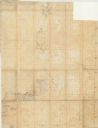
| Description: | On left side map reads: "Note by the lithographer on the Original Plat there is a Certificate of Record signed by Resister of Dane Co. also a Certificate o... |

| Date: | 1852 |
|---|---|
| Description: | Map created between 1852 and 1867 shows numbered lots, labelled roads, the "Centre Line of LaCrosse & Milwaukee R.R." railroad, and a station house. Roads ... |
| Date: | 1852 |
|---|---|
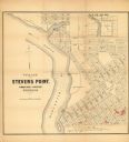
| Description: | This map of Stevens Point shows lot numbers, land reservations for steam saw mill, and Shaurette Mills. The top right features an inset map: Sec. 31 & 32, ... |

| Date: | 1852 |
|---|---|
| Description: | This map shows plat of three towns, sections, local streets, the Grand Chute Island, and part of the Fox River. The map includes 1 inset map: "Diagram of C... |
| Date: | 1852 |
|---|---|
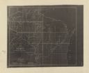
| Description: | This map shows township grid with survey progress, military posts, areas of Indian habitation, cession areas, and treaty lines. Shows the entire state of W... |
If you didn't find the material you searched for, our Library Reference Staff can help.
Call our reference desk at 608-264-6535 or email us at: