 Filter: Categories of Wisconsin Historical Images
Filter: FULL_DATE of 1853
Filter: Creator Name of Unknown
Filter: Categories of Wisconsin Historical Images
Filter: FULL_DATE of 1853
Filter: Creator Name of Unknown
| Date: | 1853 |
|---|---|
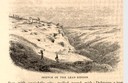
| Description: | Engraved view of miners and hillside mines in the Lead Region. Caption reads: "Sketch of the Lead Region." |
| Date: | 1853 |
|---|---|
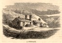
| Description: | Engraved exterior view of a lead mining furnace. A man sits in a horse-drawn wagon at the left of the building. |
| Date: | 1853 |
|---|---|
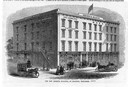
| Description: | Illustration of the new museum building, also known as "Bruen's Block," on the corner of East Washington Avenue and South Pinckney Street. Named for W.D. B... |
| Date: | 1853 |
|---|---|
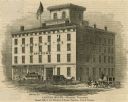
| Description: | Illustration of the Capital house, a first-class hotel, copied from page 320 of Gleason's Pictorial Drawing-Room Companion. |
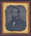
| Date: | 1853 |
|---|---|
| Description: | Sixth plate daguerreotype of Leonard J. Farwell, Governor of Wisconsin 1852-54. Quarter length facing left, wearing full beard, coat, vest, tie, and white ... |
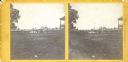
| Date: | 1853 |
|---|---|
| Description: | Stereograph of the interior of Fort Howard after its decommissioning in 1853. |

| Date: | 1853 |
|---|---|
| Description: | Engraved image of a boat being towed through a canal at Little Falls by a team of horses. A small town is in the background. |

| Date: | 1853 |
|---|---|
| Description: | Map covers area between the cities of Janesville and Kenosha in Rock, Walworth, and Kenosha counties for railroad routes. Lakes and counties are labelled. ... |

| Date: | 1853 |
|---|---|
| Description: | This facsimile map shows counties, towns, and waterways in the state of Wisconsin. Included are portions of Iowa, Michigan, and Minnesota. Lake Superior an... |
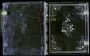
| Date: | 1853 |
|---|---|
| Description: | Case (opened to show front and back) for daguerreotype made to resemble a bound book. Mother-of-pearl decoration on front in the form of flowers, stems and... |

| Date: | 1853 |
|---|---|
| Description: | A map of Wellfleet Harbor on Cape Cod Bay. |
If you didn't find the material you searched for, our Library Reference Staff can help.
Call our reference desk at 608-264-6535 or email us at: