 Filter: Categories of Wisconsin Historical Images
Filter: FULL_DATE of 1857
Filter: Categories of Wisconsin Historical Images
Filter: FULL_DATE of 1857
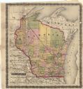
| Date: | 1857 |
|---|---|
| Description: | This map shows drainage, state boundaries, county boundaries, rivers, lakes, township lines, cities, and towns. The Milwaukee & Horicon Road road is indica... |

| Date: | 1857 |
|---|---|
| Description: | Half plate ambrotype of a drawing of the Wisconsin State Capitol. Copy of the design by Samuel Hunter Donnel and August Kutzbock, Madison architects, showi... |
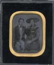
| Date: | 1857 |
|---|---|
| Description: | A seated, three-quarter length portrait of a clean shaven young man, and a young woman with a large fabric headpiece. Gold decoration has been applied to t... |
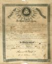
| Date: | 1857 |
|---|---|
| Description: | A certificate acknowledging the admission of Frederick Beermein to Sons of Temperance. |
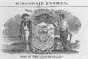
| Date: | 1857 |
|---|---|
| Description: | Great Seal of the State of Wisconsin as found in American Farmer, vol. 9. |

| Date: | 1857 |
|---|---|
| Description: | Illustration of an early design for the 3rd Wisconsin State Capitol, the second in Madison. Caption reads: "State Capitol at Madison — Donnel & Kutzbock, A... |

| Date: | 1857 |
|---|---|
| Description: | Green Lake County Abstract plat map, T. 14 N, R. 11 E. |

| Date: | 1857 |
|---|---|
| Description: | Green Lake County abstract plat map, T. 16 N, R. 11 E. |

| Date: | 1857 |
|---|---|
| Description: | Green Lake County abstract plat map, T. 17 N, R. 11 E. |

| Date: | 1857 |
|---|---|
| Description: | Green Lake County plat map, T. 15 N., R. 12 E. |

| Date: | 1857 |
|---|---|
| Description: | Green Lake County plat map, T. 14 N, R. 12 E. |

| Date: | 1857 |
|---|---|
| Description: | Green Lake County plat map, T. 16 N, R. 12 E. |

| Date: | 1857 |
|---|---|
| Description: | Green Lake County plat map, T. 17 N, R. 12 E. |

| Date: | 1857 |
|---|---|
| Description: | Green Lake County plat map, T. 14 N, R. 13 E. |

| Date: | 1857 |
|---|---|
| Description: | Green Lake County plat map, T. 15 N, R. 13 E. |

| Date: | 1857 |
|---|---|
| Description: | Green Lake County plat map, T. 16 N, R. |

| Date: | 1857 |
|---|---|
| Description: | Green Lake County plat map, T. 17 N, R. 13 E. |
If you didn't find the material you searched for, our Library Reference Staff can help.
Call our reference desk at 608-264-6535 or email us at: