 Filter: Categories of Wisconsin Historical Images
Filter: FULL_DATE of 1864
Filter: Categories of Wisconsin Historical Images
Filter: FULL_DATE of 1864
| Date: | 1864 |
|---|---|
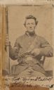
| Description: | Carte-de-visite studio portrait of 1st Lieutenant Richard Cadell seated in a chair and wearing his military uniform. He holds a rifle in his right hand and... |
| Date: | 1864 |
|---|---|
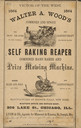
| Description: | Advertisement for self raking reaper and combined hand raker and prize mowing machine. Includes an illustration of a man using a horse-drawn reaper at the ... |

| Date: | 1864 |
|---|---|
| Description: | This map is ink, pencil, and color on paper and shows numbered lots and labeled streets. The bottom margin of the map reads: "Recorded in the Registry of d... |
| Date: | 1864 |
|---|---|
| Description: | This document, sometimes cited as the “Statement made by the Indians, a bilingual petition of the Chippewas of Lake Superior, 1864,” was carried by an Ojib... |

| Date: | 1864 |
|---|---|
| Description: | This map is pen and watercolor on paper and shows a profile and geological sections of the Blue Mounds, Hollow Run, Bogies Hollow Run, Bear Creek, East Bre... |

| Date: | 1864 |
|---|---|
| Description: | This map is pen and watercolor on paper and shows a profile and geological sections of the East Blue Mound Break, Blue Mound Creek, Black Earth River, and ... |

| Date: | 1864 |
|---|---|
| Description: | This map is pen and watercolor on paper and shows a profile and geological sections of the Apple River, Little Otter Creek, Woods' Branch, Bonners' Branch,... |

| Date: | 1864 |
|---|---|
| Description: | This map is pen and watercolor on paper and shows a profile and geological sections of the Spensley Break, James Break, Wisconsin River, and Little Bear Cr... |

| Date: | 1864 |
|---|---|
| Description: | This map is pen and pencil on paper and shows a profile of the Blue Mound and East Blue Mound. |

| Date: | 1864 |
|---|---|
| Description: | This map is pen and pencil on paper and shows a profile of the Blue Mound and East Blue Mound. |

| Date: | 1864 |
|---|---|
| Description: | This map is pen and watercolor on paper and shows a profile and the geological formation of Blue Mound. Also shown is the location of Arnold's Hotel and Br... |

| Date: | 1864 |
|---|---|
| Description: | This map shows locations of quarries, sink holes, creeks, springs, rivers, houses, forts, and roads. Annotations in pencil read: "Is the top of the mound l... |

| Date: | 1864 |
|---|---|
| Description: | This map shows locations of quarries, sink holes, creeks, springs, rivers, houses, forts, and roads. The upper right corner and right margin includes anno... |

| Date: | 1864 |
|---|---|
| Description: | Map showing locations of quarries, sink holes, creeks, springs, rivers, houses, forts, and roads. The map appears to have been drawn on to of a plat map of... |

| Date: | 1864 |
|---|---|
| Description: | This map shows locations of quarries, sink holes, creeks, springs, rivers, houses, forts, and roads. |

| Date: | 1864 |
|---|---|
| Description: | This map shows land owners, buildings, cities and villages, lakes, rivers, and roads. The margins include inset maps: Berlin; Mill Point; Holland; Ferrisvi... |

| Date: | 1864 |
|---|---|
| Description: | A flyer distributed by the U.S. Christian Commission announcing a Union Meeting "in behalf of our sick and wounded soldiers...". Several edits have been ma... |
| Date: | 1864 |
|---|---|
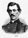
| Description: | Engraved portrait of Col. A.C. Litchfield of the 7th Michigan Cavalry. |
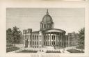
| Date: | 1864 |
|---|---|
| Description: | Engraving of the seconds Wisconsin State Capital building. This building burned down in 1904. |

| Date: | 1864 |
|---|---|
| Description: | Carte-de-visite of Nellie Noble. She is sitting sideways in a chair. Written on print: "Miss Nellie Noble of Kilbourn City, Wis. Taken in 1864." |
If you didn't find the material you searched for, our Library Reference Staff can help.
Call our reference desk at 608-264-6535 or email us at: