 Filter: Categories of Wisconsin Historical Images
Filter: FULL_DATE of 1960
Filter: County of Milwaukee
Filter: Categories of Wisconsin Historical Images
Filter: FULL_DATE of 1960
Filter: County of Milwaukee

| Date: | 1960 |
|---|---|
| Description: | A father is holding his young son in his arms. |
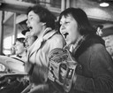
| Date: | 1960 |
|---|---|
| Description: | Close-up of fans shouting at a Milwaukee Braves baseball game. |
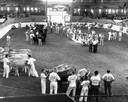
| Date: | 1960 |
|---|---|
| Description: | An audience watches and judges stand by as cattle are lined up to be judged in a pavilion at the Wisconsin State Fair. |
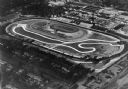
| Date: | 1960 |
|---|---|
| Description: | The State Fairgrounds where a 200-mile "big car" race took place. The park is one of the five largest outdoor expositions in the country. |

| Date: | 1960 |
|---|---|
| Description: | Statue of the monk with a cross in his left hand and his right hand upraised. Behind the statue is a plaque with a carving of an Indian in a canoe near a s... |
| Date: | 1960 |
|---|---|
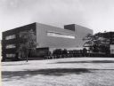
| Description: | Administration Building. A two-story building with an sign and a symbol of a tall beer of glass flanked by two stalks of a plant on the front entrance of t... |
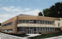
| Date: | 1960 |
|---|---|
| Description: | An adjunct of the Milwaukee Vocational and Adult Schools. |
| Date: | 1960 |
|---|---|
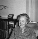
| Description: | Portrait of Laura Graf seated in a chair at her home in Wauwatosa, Wisconsin. A bookcase is behind her. Laura was born September 2, 1898 in Pewaukee (Wa... |

| Date: | 1960 |
|---|---|
| Description: | Color coded map in pink, yellow, blue, and brown of Milwaukee County State and County trunk highways. The map includes a legend of symbols: "STEAM RAIL ROA... |

| Date: | 1960 |
|---|---|
| Description: | This map of Greedale shows local streets, parks, schools, and churches and includes manuscript annotations in green and blue showing tracts and parcels of ... |

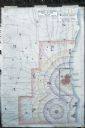
| Date: | 1960 |
|---|---|
| Description: | This blue print map shows village limits, collector residential streets, and primary residential streets. The upper right corner features a key to street t... |

| Date: | 1960 |
|---|---|
| Description: | This blue line print shows state and city maintained roads, as well as government land, parks, Milwaukee Co. Park Commission, golf courses, schools, City o... |
| Date: | 1960 |
|---|---|
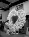
| Description: | Two women are assembling a large paper valentine decoration. One woman stands on a ladder in front of a fireplace working on the top of the decoration, whi... |

| Date: | 1960 |
|---|---|
| Description: | William Behnke selling out after 60 years as the neighborhood grocer at North Avenue and 29th Street. There are four people behind the counter, and custome... |

| Date: | 1960 |
|---|---|
| Description: | Construction Equipment Division. |
| Date: | 1960 |
|---|---|
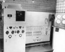
| Description: | Caption reads: "Baird Direct Reading Spectrometer." |
| Date: | 1960 |
|---|---|
| Description: | Map showing the probable blast radius of a 20 megaton bomb on Milwaukee. The map also shows existing hospitals in the area, including outside Milwaukee Cou... |
If you didn't find the material you searched for, our Library Reference Staff can help.
Call our reference desk at 608-264-6535 or email us at: