 Filter: Categories of Wisconsin Historical Images
Filter: FULL_DATE of 1994
Filter: Subject of transportation
Filter: Categories of Wisconsin Historical Images
Filter: FULL_DATE of 1994
Filter: Subject of transportation

| Date: | 1994 |
|---|---|
| Description: | Front cover of an advertising brochure for the International Eagle Pro Sleeper semi tractor. Features a color photograph of the truck against a bright blue... |
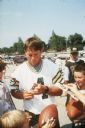
| Date: | 1994 |
|---|---|
| Description: | Green Bay Packer quarterback Brett Favre signing autographs for kids in the parking lot of Lambeau Field, near the Packer practice field. This photograph w... |

| Date: | 1994 |
|---|---|
| Description: | The buildings behind the east Lincoln Highway. |

| Date: | 1994 |
|---|---|
| Description: | Hintzsche Fertilizer on the East Lincoln Highway. |

| Date: | 1994 |
|---|---|
| Description: | Covered automobile with snow off the East Lincoln Highway. |

| Date: | 1994 |
|---|---|
| Description: | Coal chute on the railroad tracks on the east end of DeKalb. |

| Date: | 1994 |
|---|---|
| Description: | Train on the railroad tracks through town. |

| Date: | 1994 |
|---|---|
| Description: | This brochure consists of a series of 16 maps of the Elroy-Sparta State Trail and the 400 State Trail, as well as the Omaha Trail between Sparta and Camp D... |

| Date: | 1994 |
|---|---|
| Description: | This brochure presents a series of 16 maps of the Glacial Drumlin Trail and the New Berlin Trail. The Glacial Drumlin Trail consists of 53 miles of bike tr... |

| Date: | 1994 |
|---|---|
| Description: | This brochure consists of a series of 16 maps of the Military Ridge State Park Trail and the Sugar River State Trail. In all, 62 miles of bike trails and 1... |

| Date: | 1994 |
|---|---|
| Description: | "Blacktop is being laid at this intersection in the Village of Theresa." |
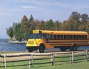
| Date: | 1994 |
|---|---|
| Description: | Color photograph of an International 3600 Vista school bus on a gravel road along a shoreline. There is a man in the driver's seat. In the foreground is a ... |

| Date: | 1994 |
|---|---|
| Description: | Congressman David Obey on a diplomatic airplane with a group of seated colleagues. He is standing on the right. |

| Date: | 1994 |
|---|---|
| Description: | This map shows historical sites, picnic grounds, public boat landings, canoe and motor boat trips, and resort locations. The left margin of the map include... |
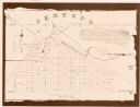
| Date: | 1994 |
|---|---|
| Description: | This cadastral map shows Mill Pond, buildings, some landowners, cemetery, and out-lots. The upper right corner includes a statement about Ceresco. |
If you didn't find the material you searched for, our Library Reference Staff can help.
Call our reference desk at 608-264-6535 or email us at:

