 Filter: Categories of Wisconsin Historical Images
Filter: Subject of Astronomy
Filter: Type of Map or Atlas
Filter: Categories of Wisconsin Historical Images
Filter: Subject of Astronomy
Filter: Type of Map or Atlas
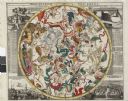
| Date: | 1745 |
|---|---|
| Description: | Zodiac as seen from the Northern Hemisphere. |
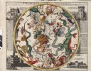
| Date: | 1745 |
|---|---|
| Description: | Zodiac as seen from the Southern Hemisphere. |
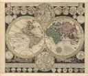
| Date: | 1745 |
|---|---|
| Description: | A two page world map featuring the Eastern and Western Hemispheres, as well as the northern and southern zodiacs. Additionally, the map is ordained with n... |

| Date: | 1712 |
|---|---|
| Description: | Engraved double-hemispherical world map by Moll, included in his atlas The world described, or, A new and correct sett of maps: shewing the kingdoms and st... |

| Date: | 1760 |
|---|---|
| Description: | A map of the world in two hemispheres, with the borders of the continents hand-colored. This map contains 14 spherical diagrams of the cosmos, portraying t... |

| Date: | 1746 |
|---|---|
| Description: | This world map from the German mathematician, historian, and geographer Johann Matthias Hase shows the major cities, islands, and the major political divis... |

| Date: | 1775 |
|---|---|
| Description: | This six sheet large format map is one of the most informative maps of its time. It shows cities, Native American land, lakes, rivers, mountains, topograph... |
If you didn't find the material you searched for, our Library Reference Staff can help.
Call our reference desk at 608-264-6535 or email us at: