 Filter: Categories of Wisconsin Historical Images
Filter: Subject of Drawing
Filter: Year of 1700-1799
Filter: Categories of Wisconsin Historical Images
Filter: Subject of Drawing
Filter: Year of 1700-1799
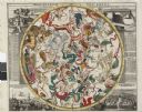
| Date: | 1745 |
|---|---|
| Description: | Zodiac as seen from the Northern Hemisphere. |
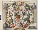
| Date: | 1745 |
|---|---|
| Description: | Zodiac as seen from the Southern Hemisphere. |
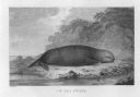
| Date: | 1784 |
|---|---|
| Description: | Plate 43. Scene from Cook's Third Expedition, 1776-1779, while in Alaska. |

| Date: | 1784 |
|---|---|
| Description: | Plate 45. Scene from Cook's Third Expedition, 1776-1779, while in Alaska. |

| Date: | 1712 |
|---|---|
| Description: | This drawing, based on an 1897 survey, appeared in the 1899 Proceedings of the State Historical Society of Wisconsin, accompanying Publius V. Lawson's arti... |

| Date: | 1774 |
|---|---|
| Description: | A hand-drawn plat map of Elkcorn (Elkhorn?) Creek. |
If you didn't find the material you searched for, our Library Reference Staff can help.
Call our reference desk at 608-264-6535 or email us at: