 Filter: Categories of Wisconsin Historical Images
Filter: Subject of Great Lakes
Filter: Categories of Wisconsin Historical Images
Filter: Subject of Great Lakes

| Date: | 1883 |
|---|---|
| Description: | A hand-colored map of Wisconsin showing counties, cities, villages, railroads, lakes, and rivers in the state. The map also includes the eastern portions o... |

| Date: | 1884 |
|---|---|
| Description: | A detailed, hand-colored map of Wisconsin and the western portion of Michigan’s Upper Peninsula, which also includes an inset of Isle Royale in Lake Superi... |
| Date: | 1885 |
|---|---|
| Description: | A hand-colored map of Wisconsin that also includes eastern Minnesota and Iowa, northern Illinois, and the Upper Peninsula of Michigan showing the counties,... |

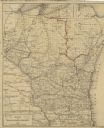
| Date: | 1885 |
|---|---|
| Description: | A hand-colored map of Wisconsin showing the railroads, counties, cities, towns, rivers, and lakes in the state. Also included in the map are the eastern po... |

| Date: | 06 1887 |
|---|---|
| Description: | A map of southern Wisconsin, from the Illinois state border in the south to Rocky Run, Wisconsin in the north for the Coast and Geodetic Survey, showing th... |
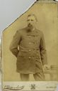
| Date: | |
|---|---|
| Description: | Three-quarter length cabinet card portrait of Captain N.A. Peterson, a native of Milwaukee, Wisconsin, who was master and part owner of the schooner “Selt”... |

| Date: | 1836 |
|---|---|
| Description: | This map depicts Wisconsin and Michigan territories in 1836. It includes the area from Michigan to the Missouri River and Lake Winnipeg, and it shows the e... |

| Date: | 1839 |
|---|---|
| Description: | Wisconsin was considered part of Michigan Territory until 1836, a year before Michigan entered statehood. Drawn in 1839, this map shows the state of Michig... |

| Date: | 1844 |
|---|---|
| Description: | Wisconsin was considered part of Michigan Territory until 1836, a year before Michigan entered statehood. Drawn four years before Wisconsin entered stateho... |

| Date: | 1845 |
|---|---|
| Description: | Wisconsin was considered part of Michigan Territory until 1836, a year before Michigan entered statehood. Drawn three years before Wisconsin entered stateh... |

| Date: | 1855 |
|---|---|
| Description: | Drawn seven years after Wisconsin entered statehood, this map shows the counties, cities, towns, rivers and lakes in the entire state. The map includes a c... |

| Date: | 1858 |
|---|---|
| Description: | Drawn a decade after Wisconsin entered statehood, this 1858 map depicts counties, creeks, rivers, lakes, railroads completed, railroads in progress and com... |

| Date: | 1855 |
|---|---|
| Description: | This map depicts counties, creeks, rivers, lakes, railroads completed, railroads in progress, common roads and the Menomonee Reservation. |

| Date: | 1874 |
|---|---|
| Description: | This map of Wisconsin shows cities, counties, railroads already completed and railroads projected, and geological makeup of the land such as lakes. |

| Date: | 1858 |
|---|---|
| Description: | This map shows the railroads in southern Wisconsin and their connections with points in Iowa and Illinois. An inset map shows rail connections between sout... |

| Date: | 1911 |
|---|---|
| Description: | This map of Wisconsin, the western portion of Michigan's Upper Peninsula, and northern Illinois shows counties, towns, cities and villages, rivers and lake... |

| Date: | 02 1823 |
|---|---|
| Description: | A map featuring the North American expedition from Pittsburgh to the Rocky Mountains led by Edwin James. |

| Date: | 1904 |
|---|---|
| Description: | A young Aldo Leopold is posing smiling, wearing a jacket and bow tie while sitting on a pier. He is vacationing in the Cheneaux Islands. A shoreline with b... |

| Date: | 1906 |
|---|---|
| Description: | A hand-colored commercial map of Wisconsin and portions of eastern Minnesota, Iowa, northern Illinois, and the Michigan’s Upper Peninsula. The map shows ra... |

| Date: | |
|---|---|
| Description: | An ink, watercolor, and pencil on paper, hand-drawn map that shows the Michigan-Wisconsin boundary in Iron, Vilas, Forest, Florence, and Marinette counties... |
If you didn't find the material you searched for, our Library Reference Staff can help.
Call our reference desk at 608-264-6535 or email us at: