Filter: Categories of Wisconsin Historical Images
Filter: Subject of Great Plains
Filter: Subject of arts
Filter: Categories of Wisconsin Historical Images
Filter: Subject of Great Plains
Filter: Subject of arts
| Date: | |
|---|---|
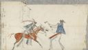
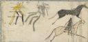
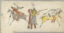
| Description: | Ledger Drawing. Two men in battle. Two horses, one with a rider dressed entirely in black. |
| Date: | |
|---|---|
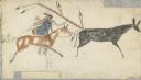
| Description: | Ledger Drawing. Two men in combat, one on horseback with a spear or coup stick. |
| Date: | |
|---|---|
| Description: | Ledger Drawing. Two men, one horse. One man touches the other with what may be a coup stick. |
| Date: | |
|---|---|
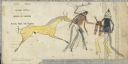
| Description: | Ledger Drawing. Two horses, one ridden by a man with long spear or coup stick. Second man drawn in pencil, not colored. |
| Date: | |
|---|---|
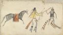
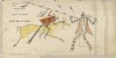
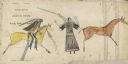
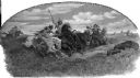
| Description: | Ledger Drawing. Three men, two on horseback riding in opposite directions. Third standing, firing a gun. |
| Date: | |
|---|---|
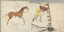
| Description: | Ledger Drawing. Two horses, one ridden by a man with spear or coup stick. |
| Date: | |
|---|---|
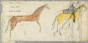
| Description: | Ledger Drawing. Two men, two horses, one ridden by one of the men. |
| Date: | |
|---|---|
| Description: | Ledger Drawing. Two men, one prone, the other touching him with what may be a coup stick. |
| Date: | 1907 |
|---|---|
| Description: | Photograph of a painting of Native Americans hunting buffalo with spears and bows. Text on photograph reads: "Grand Forks, N.D. Buffalo Hunting- Olden Time... |

| Date: | 1902 |
|---|---|
| Description: | Painting of a group of bison surrounding a prostrate dead Indian warrior with arrows protruding from his chest and half buried in the snow. |

| Date: | 1688 |
|---|---|
| Description: | This map includes vignettes of Amerindian life with text describing geography, culture, and exploration activity, written in French. The Great Lakes, river... |

| Date: | 1718 |
|---|---|
| Description: | This map shows the Mississippi River, with latitude and longitude coordinates, ad covers east to Lake Ontario and south to Illinois. The inset map (the top... |

| Date: | 1720 |
|---|---|
| Description: | Map showing the course of the Mississippi River from the Gulf of Mexico up past Lake Superior into Canada. It shows the towns, Native American tribes and l... |
If you didn't find the material you searched for, our Library Reference Staff can help.
Call our reference desk at 608-264-6535 or email us at: