 Filter: Categories of Wisconsin Historical Images
Filter: Subject of Hiking
Filter: Community of Baraboo
Filter: Categories of Wisconsin Historical Images
Filter: Subject of Hiking
Filter: Community of Baraboo

| Date: | 1949 |
|---|---|
| Description: | This map shows points of interest, historic sites, buildings, trails, roads, and general animal and plant locations. |
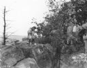
| Date: | 09 1934 |
|---|---|
| Description: | A male guide on the left is using a walking stick to point out a feature in the rocks atop a bluff at Devil's Lake State Park, as a group of men on the rig... |

| Date: | 1935 |
|---|---|
| Description: | A young man wearing a hat, short pants, and a rucksack is standing atop a high rock formation looking down at Devil's Lake. There are wooded bluffs in the ... |
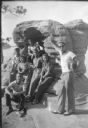
| Date: | 1939 |
|---|---|
| Description: | A young man wearing a cap and sunglasses is posing standing with his right hand resting on a rock formation. He is holding a Kodak Brownie No. 2A box camer... |
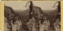
| Date: | |
|---|---|
| Description: | Stereograph of an elevated view of a man posing on a rocky outcropping near bluffs, with a valley in the distance. Text on the reverse: "K?iks Valley, Devi... |
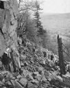
| Date: | 1945 |
|---|---|
| Description: | University students on a field trip to Devil's Lake State Park climb the trail up through the piles of talus (broken rocks) on the slope. A couple in the f... |
If you didn't find the material you searched for, our Library Reference Staff can help.
Call our reference desk at 608-264-6535 or email us at: