Filter: Categories of Wisconsin Historical Images
Filter: Subject of Lac du Flambeau
Filter: Year of 1900-1999
Filter: Categories of Wisconsin Historical Images
Filter: Subject of Lac du Flambeau
Filter: Year of 1900-1999
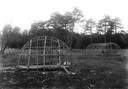
| Date: | 1929 |
|---|---|
| Description: | Framework for a Chippewa (Ojibwa) wigwam (left) and long medicine lodge at Lac du Flambeau. This image is part of an exhibit about Native Americans prepare... |
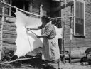
| Date: | 1925 |
|---|---|
| Description: | Native American settlement. This photograph is thought to represent a view of the Chippewa (Ojibwa) settlement at Lac du Flameau. Probably photographed by ... |
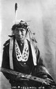
| Date: | 1913 |
|---|---|
| Description: | A postcard of a Native American (Ojibwa) at Lac du Flambeau, Wisconsin. This image is part of an exhibit about Native Americans prepared by Paul Vanderbilt... |

| Date: | 10 1936 |
|---|---|
| Description: | A nurse poses outdoors holding a Native American girl at the Lac du Flambeau Indian reservation. |
| Date: | 1934 |
|---|---|
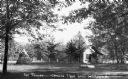
| Description: | View of a one-story log lodge, the Tavern - Crawling Stone Lodge, and a tipi with trees in the background and foreground. There is a lake behind the lodge. |

| Date: | 1922 |
|---|---|
| Description: | A map of Iron County, Wisconsin, shows sections and the towns of Upson, Hurley, Hamilton, Saxon, and Mercer, lakes and streams, villages, railroads, roads ... |

| Date: | 1932 |
|---|---|
| Description: | A map of Iron County, Wisconsin, shows towns and sections, lakes and streams, villages, railroads, roads, and La Point and Lac Du Flambeau Indian reservati... |

| Date: | 1939 |
|---|---|
| Description: | This illustrated map shows counties, highways, rivers, roads, present and proposed state parks and forests, proposed state parkways, proposed state monumen... |

| Date: | 1911 |
|---|---|
| Description: | This map shows railroads, roads, swamps, a school site and farm, and a mill site. The map includes a "typical township" diagram. Lac du Flambeau, Long Lake... |

| Date: | 1935 |
|---|---|
| Description: | This map shows railroads, telephone lines, roads, trails, schools, sub-agency, lookout stations, churches, community centers, and school site and farm. Bil... |

| Date: | 1994 |
|---|---|
| Description: | This map shows historical sites, picnic grounds, public boat landings, canoe and motor boat trips, and resort locations. The left margin of the map include... |
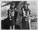
| Date: | 1936 |
|---|---|
| Description: | Walker Reid (1929-2016) standing alongside tree with Indian girl. Reid Walker shown is 7-years-old, and is the son of Carol McMillan Reid. Portrait taken a... |
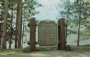
| Date: | 1969 |
|---|---|
| Description: | Historical marker on the shore of Flambeau Lake. Erected 1937. |
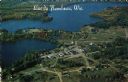
| Date: | 1984 |
|---|---|
| Description: | Aerial postcard of Lac du Flambeau village and surrounding lakes. Caption reads: "Lac du Flambeau, Wis." Text on reverse reads: "On State Hwy 47 between Po... |
If you didn't find the material you searched for, our Library Reference Staff can help.
Call our reference desk at 608-264-6535 or email us at: