 Filter: Categories of Wisconsin Historical Images
Filter: Subject of Land companies
Filter: Categories of Wisconsin Historical Images
Filter: Subject of Land companies
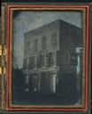
| Date: | 1855 |
|---|---|
| Description: | Quarter plate ambrotype of a brick structure, possibly in Green Bay, Wisconsin, housing the office of J.S. Baker, Land Agent. The building is three stories... |
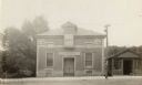
| Date: | 1925 |
|---|---|
| Description: | The Knights of Pythias Castle Hall, formerly the Presbyterian Church, dedicated in 1844. The small building to the right of the church was built and occupi... |
| Date: | 1851 |
|---|---|
| Description: | Engraving of the five-story tall mill erected at the outlet of the Yahara Creek by Leonard J. Farwell. This engraving appears in Statistics of Dane County,... |
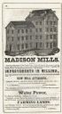
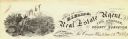
| Date: | 1855 |
|---|---|
| Description: | Advertisment of Leonard J. Farwell from the 1855 Madison City Directory for the real estate property he had for sale. At the time Farwell was the largest ... |

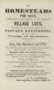
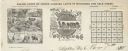
| Date: | 1836 |
|---|---|
| Description: | Lots to be sold at auction by Van Antwerp and Van Dyke on Monday, 3rd Oct. 1836. The map shows plots and labeled streets. Iowa County was later split and B... |
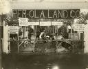
| Date: | |
|---|---|
| Description: | Man standing in a booth promoting the Per-Ola Land Company. There are several Forest County grown grains and crops on display in the booth to show the boun... |

| Date: | 1886 |
|---|---|
| Description: | Wisconsin map showing land offices, railroads completed, railroad land grants and Indian reservations. |

| Date: | 1909 |
|---|---|
| Description: | Map of Sawyer County with an advertisement for land sales through Fuley & Quail of Hayward, Wisconsin. There is a small inset map of railroads accessible i... |
| Date: | |
|---|---|
| Description: | Letterhead of Baldwin & Killen Lands and W.H. Killen & Company, dealers of farm, lumber, and mineral lands, from Appleton, Wisconsin, with an image on the ... |

| Date: | 1896 |
|---|---|
| Description: | This hand-colored map shows counties, county seats, cities, towns, proposed and completed railroads, and U.S. Land Offices. Also included in the map are th... |

| Date: | 1896 |
|---|---|
| Description: | A map showing the Wisconsin Central Railroad lines in Wisconsin, northern Illinois, eastern Minnesota, and Michigan’s Upper Peninsula. The area of the map ... |

| Date: | 1900 |
|---|---|
| Description: | A map of Wisconsin, eastern Minnesota and Iowa, northern Iowa, and Michigan’s Upper Peninsula, showing railway lines, with those marked with heavy red line... |

| Date: | 1900 |
|---|---|
| Description: | A map of Wisconsin, eastern Minnesota and Iowa, and Michigan’s Upper Peninsula, showing the rail lines of the Wisconsin Central Railroad are shown in red, ... |
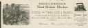
| Date: | |
|---|---|
| Description: | Letterhead of John J. Sherman, a real estate broker and tax, title, collection, and passenger agent in Wausau, Wisconsin, with images of men felling trees ... |
| Date: | |
|---|---|
| Description: | Letterhead of H.I. Bliss, a real estate agent, civil engineer, and county surveyor in La Crosse, Wisconsin. On the left a group of three men are surveying ... |

| Date: | 1864 |
|---|---|
| Description: | A hand-colored survey map of southeastern Minnesota and Wisconsin, showing the locations of railroads, land grant railroads, land offices, and the 6 and 15... |

| Date: | 1881 |
|---|---|
| Description: | A brochure with a map of Wisconsin that also includes information (in English, German, Norwegian, and Swedish) pertaining to the state, such as its timber ... |
| Date: | 1888 |
|---|---|
| Description: | Map of northern Wisconsin showing the Chicago and North-Western Railway Company’s land grants within the counties of Forest, Florence, Langlade, Marinette,... |
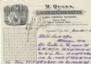
| Date: | |
|---|---|
| Description: | Letterhead of M. Quinn, "Dealer in Pine Lands," with two men in front of a tent at a campsite, one of whom is cooking over a campfire and the other is sitt... |

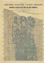
| Date: | 1875 |
|---|---|
| Description: | This manuscript map shows the limits of the land grants made to railroads in northwestern Wisconsin along the corridor between Portage and Hudson, along th... |
If you didn't find the material you searched for, our Library Reference Staff can help.
Call our reference desk at 608-264-6535 or email us at: