Filter: Categories of Wisconsin Historical Images
Filter: Subject of Maps
Filter: Creator Name of Unknown
Filter: Categories of Wisconsin Historical Images
Filter: Subject of Maps
Filter: Creator Name of Unknown

| Date: | 07 1838 |
|---|---|
| Description: | A map diagram of Indian effigy mounds seven miles east of Blue Mounds in the Wisconsin Territory. |
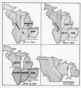
| Date: | 01 11 1805 |
|---|---|
| Description: | Four map illustrations showing the political subdivisions of the Northwest Territory from 1805 through 1834. |

| Date: | 1926 |
|---|---|
| Description: | Pages 21 and 22 from the 1926 schedule are a map showing the routes of the Goodrich Transit Company, Great Lakes Transit Company, Detroit and Cleveland Lin... |
| Date: | 1930 |
|---|---|
| Description: | Page 4 from the schedule describes the trip from Chicago, Illinois, to Milwaukee, Wisconsin, on the "Christopher Columbus" or "Theodore Roosevelt". Include... |

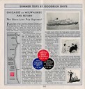
| Date: | 1930 |
|---|---|
| Description: | Page 8 of the 1930 schedule is a map of the routes of the Goodrich Steamship Lines in Lake Michigan and Lake Huron. |

| Date: | 1780 |
|---|---|
| Description: | Hand-drawn plan for the layout of the town of Clarksville, bordering Mayfield Creek and Liberty Creek. Fort Jefferson is shown between the townsite and the... |

| Date: | |
|---|---|
| Description: | A tea party on an airplane, a publicity stunt conceived by Harry Bruno to promote his Cleveland-area airline, Aeromarine Airlines. By taking local reporter... |
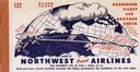
| Date: | 1948 |
|---|---|
| Description: | Passenger ticket and baggage check for Northwest Orient Airlines, illustrating their newly initiated around-the-globe routes to the Far East. This ticket w... |

| Date: | 1905 |
|---|---|
| Description: | Bird's-eye view of Manitowoc on the shores of Lake Michigan. A map of the northeastern part of the United States at the top indicates Manitowoc's location ... |

| Date: | 1836 |
|---|---|
| Description: | The map of Wisconsin City on the Wisconsin River. |

| Date: | |
|---|---|
| Description: | Sketch of the Fort at Michilimackinac (also called Mackinac) as it was under French rule. |
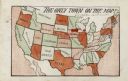
| Date: | 1905 |
|---|---|
| Description: | Map of the United States with an imprint of Whitewater, Wisconsin and the title "The Only Town on the Map". It was published as a novelty. |

| Date: | 1920 |
|---|---|
| Description: | Calumet Harbor on Lake Winnebago. On the left is a map, and on the right are two images, one captioned: "Calumet Harbor". |

| Date: | 1910 |
|---|---|
| Description: | Aerial view of some of the 26 lakes known collectively as the Chain O' Lakes. Caption reads: "Aeroplane View of Chain O'Lakes, Waupaca, Wis." |

| Date: | 1971 |
|---|---|
| Description: | Secretary of Defense Melvin Laird, wearing a fatigue uniform, shaking hands with a military officer during a tour of Vietnam. |
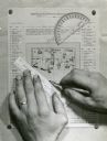
| Date: | |
|---|---|
| Description: | Person's hands, one with with wedding ring on left hand, using a ruler, pencil, and protractor to draw a land cover map for Wisconsin Land Economic Invento... |

| Date: | 1917 |
|---|---|
| Description: | The Lake Forest community plan, a model community that was planned for the site where the University of Wisconsin Arboretum now stands. |

| Date: | 1925 |
|---|---|
| Description: | A map of the farm planned by Edwin Bottomley in 1844. |
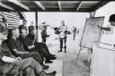
| Date: | 1971 |
|---|---|
| Description: | Secretary of Defense Melvin Laird, and several cigar-smoking officers are listening to a presentation about the war in Vietnam. |
If you didn't find the material you searched for, our Library Reference Staff can help.
Call our reference desk at 608-264-6535 or email us at: