 Filter: Categories of Wisconsin Historical Images
Filter: Subject of Maps
Filter: Community of Mineral Point
Filter: Categories of Wisconsin Historical Images
Filter: Subject of Maps
Filter: Community of Mineral Point

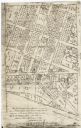
| Date: | 1850 |
|---|---|
| Description: | Lithograph of a map drawn to indicate a mine on land owned by Mineral Point Mining Co. in the lead region of southwestern Wisconsin. |
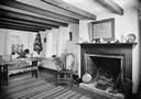
| Date: | 1936 |
|---|---|
| Description: | View of a room in Pendarvis House. There is a map of Cornwall over the fireplace. A bedwarmer and a bellows sit at the base of the hearth. |
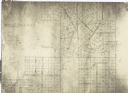
| Date: | 1900 |
|---|---|
| Description: | This facsimile of manuscript map shows lot numbers, dimensions, streets, and township lines. The bottom left corner includes a certification. |
| Date: | 1900 |
|---|---|
| Description: | This facsimile of a manuscript map shows lots and streets. The lower left corner includes a certification. |
If you didn't find the material you searched for, our Library Reference Staff can help.
Call our reference desk at 608-264-6535 or email us at: