Filter: Categories of Wisconsin Historical Images
Filter: Subject of Michigan, Lake
Filter: Categories of Wisconsin Historical Images
Filter: Subject of Michigan, Lake
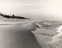
| Date: | 1965 |
|---|---|
| Description: | The Lake Michigan shoreline in the Kohler-Andrae State Park, named after John Michael Kohler and Terry Andrae. |
| Date: | 1965 |
|---|---|
| Description: | The sand dunes in Kohler-Andrae State Park, named after John Michael Kohler and Terry Andrae. |
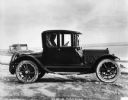
| Date: | 1914 |
|---|---|
| Description: | A 1914 Cadillac sitting near Lake Michigan. Its body was produced by the W.S. Seaman Company. |

| Date: | 1844 |
|---|---|
| Description: | Map of Wisconsin including Lakes Michigan and Superior. Inset includes "N.W. Part of Wiskonsan." |

| Date: | 1941 |
|---|---|
| Description: | Official highway map of Wisconsin, "the playground of the Midwest," showing the state transportation network prior to World War II. |
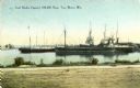
| Date: | 1900 |
|---|---|
| Description: | View from shoreline towards the coal docks on the right, with several ships in the harbor. Caption reads: "Coal Docks, Capacity 100,000 Tons, Two Rivers, W... |
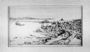
| Date: | 1914 |
|---|---|
| Description: | View of Sturgeon Bay with the Teweles & Brandeis flour mill across the water on the left. |
| Date: | |
|---|---|
| Description: | View of a U.S. lighthouse and Coast Guard station. |
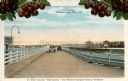
| Date: | 1920 |
|---|---|
| Description: | View of two automobiles crossing a toll bridge. There are cherries on branches at the top of the postcard. Caption reads: "In Door County 'Cherryland,' The... |

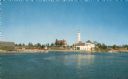
| Date: | 1953 |
|---|---|
| Description: | View across water towards the Sturgeon Bay Canal Lighthouse, with a group of people in a motorboat in the foreground. |
| Date: | 1915 |
|---|---|
| Description: | Colorized view of the Sherwood Point Lighthouse. Caption reads: "Sherwood Point Light House, Sturgeon Bay, Wis." |
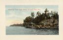
| Date: | 1910 |
|---|---|
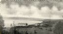
| Description: | View of Sawyer Harbor as seen from Government Bluff. |
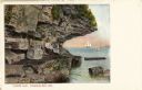
| Date: | 1910 |
|---|---|
| Description: | View of Lover's Leap, with a group of people posing on the rocks and sailboats in the background. Caption reads: "Lover's Leap, Sturgeon Bay, Wis." |
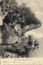
| Date: | 1906 |
|---|---|
| Description: | View of Lover's Leap with a group of people on the rocks near the shoreline under an overhang. Caption reads: "Lovers Leap, Sturgeon Bay, Wis." |

| Date: | 1907 |
|---|---|
| Description: | The Ruins of the old Light House on Plum Island near Sturgeon Bay. Caption at bottom reads: "Ruins of Old Light House on Plum Island," "Made expressly for ... |
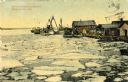
| Date: | 1910 |
|---|---|
| Description: | A springtime harbor scene from Sturgeon Bay. Chunks of ice are floating on the surface of the water. Caption reads: "Harbor scene at springtime. Sturgeon B... |

| Date: | 1875 |
|---|---|
| Description: | The harbor piers and the entrance to the Sturgeon Bay ship canal. Men are standing on the shoreline. |

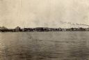
| Date: | 1950 |
|---|---|
| Description: | An aerial view of town, showing a major industrial area. |
If you didn't find the material you searched for, our Library Reference Staff can help.
Call our reference desk at 608-264-6535 or email us at: