 Filter: Categories of Wisconsin Historical Images
Filter: Subject of Municipal services
Filter: Year of 1800-1899
Filter: Categories of Wisconsin Historical Images
Filter: Subject of Municipal services
Filter: Year of 1800-1899
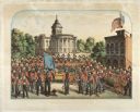
| Date: | 1857 |
|---|---|
| Description: | A lithographic portrait by Louis Kurz (1833-1921) of Madison Fire Engine Company #2 posed with a hand pumper and hose cart in front of the design of the ne... |
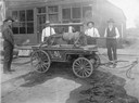
| Date: | 1887 |
|---|---|
| Description: | Peter Selb, Ben Dietrich, J.A. Lockwood, Matt Dietrich, and John Downing pose around the hand engine of the volunteer fire department. All but Selb were ch... |

| Date: | 1887 |
|---|---|
| Description: | Bird's-eye view of the Wisconsin Fish Hatchery at Fitchburg. |
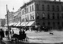
| Date: | 1895 |
|---|---|
| Description: | A hose wagon of the Madison fire department racing around the corner of North Pinckney and East Main streets. A dog is chasing the wagon. |
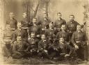
| Date: | 1870 |
|---|---|
| Description: | E.W. Keyes Steam Fire Engine Company Number 1, Madison Fire Department, organized in 1866. |

| Date: | 1880 |
|---|---|
| Description: | This map is pen-and-ink on paper. The map shows buildings, trees, and water and gas pipes, relief is shown by contours. The back of the map reads: "Univers... |

| Date: | 1887 |
|---|---|
| Description: | Shows pipes of various sizes, hydrants with hydrant pressure, valves, wells, and projected lines. |

| Date: | 1892 |
|---|---|
| Description: | Shows pipes of various sizes, hydrants with hydrant pressure, valves, wells, and projected lines. Differs from earlier versions by inclusion of Wingra Park... |

| Date: | 1896 |
|---|---|
| Description: | Shows pipes of various sizes, hydrants with hydrant pressure, valves, wells, projected lines, and suction pipes. Differs from earlier versions by inclusion... |

| Date: | 1894 |
|---|---|
| Description: | This map shows lot and block numbers, railroads, street car tracks, sewers, water mains, gas mains, paved streets, land owned by the Land & River Improveme... |

| Date: | 1892 |
|---|---|
| Description: | This map shows water pipes, hydrants, stop cocks, check valves, fire cysterns, and manholes. Also shown are block numbers, streets, railroads, parks, cemet... |

| Date: | 1894 |
|---|---|
| Description: | This map shows sewers, intercepting sewers, manholes, block numbers, streets, railroads, parks, cemeteries, and Lake Michigan. The right margin reads: "Tot... |

| Date: | 1887 |
|---|---|
| Description: | This map shows sewers, manholes, streets, canals, rivers, and Lake Michigan. An explanation of sewer types is included. |
If you didn't find the material you searched for, our Library Reference Staff can help.
Call our reference desk at 608-264-6535 or email us at: