 Filter: Categories of Wisconsin Historical Images
Filter: Subject of Revolution, 1775-1783
Filter: Categories of Wisconsin Historical Images
Filter: Subject of Revolution, 1775-1783
| Date: | 1799 |
|---|---|
| Description: | Map of the United States east of the Mississippi River. It shows borders, treaty lines, forts, cities, towns, Native American land, mountains, swamps, lake... |

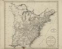
| Date: | 1792 |
|---|---|
| Description: | Map of the United States east of the Mississippi River and north of the Ohio River. It shows the borders between the north eastern states, Canada and the U... |

| Date: | 1775 |
|---|---|
| Description: | Map of Boston and surrounding regions, from Massachusetts Bay to the Connecticut River, and including part of southern New Hampshire. It shows the colonies... |

| Date: | 1780 |
|---|---|
| Description: | Detailed topographical and political map of the area from Lake Champlain to Albany and the Hudson River. Relief is shown through hachures. The map shows ci... |

| Date: | 1795 |
|---|---|
| Description: | Detailed map of New York, showing counties, cities, mines, mills, roads, swamps, mountains, lakes and rivers. The map also shows Native American towns and ... |

| Date: | 1778 |
|---|---|
| Description: | Map of the land between Fort Ticonderoga and Albany. It shows cities, forts, mills, roads, mountains, swamps, waterfalls, lakes, and rivers. A few annotati... |

| Date: | 10 1776 |
|---|---|
| Description: | Broadside map showing the British invasion of New York city in August and September of 1776. The map shows important cities, forts, roads, hills, mountains... |

| Date: | 02 1777 |
|---|---|
| Description: | Map depicting the campaigns of October and November 1776, in Manhattan, Westchester, and part of New Jersey, published only a few months after the conclusi... |

| Date: | 03 1777 |
|---|---|
| Description: | Map showing the British and Hessian attack on Fort Washington in November of 1776. The movements and fortifications of the British and Hessian troops appea... |

| Date: | 11 1781 |
|---|---|
| Description: | Map of New York, Staten Island, and Long Island, showing the placements of forts, and the movement of troops in 1776. The map also includes towns, cities, ... |

| Date: | 1776 |
|---|---|
| Description: | Fairly detailed map of New York City and parts of Long Island. It shows streets, roads, wharves, ferries, ship yards, Fort George and the battery, public b... |

| Date: | 04 1777 |
|---|---|
| Description: | Map showing the area from Newtown, Pennsylvania to Kingston, New Jersey, with routes and battles of British (red) and American forces (blue). The map inclu... |

| Date: | 1781 |
|---|---|
| Description: | Map of North and South Carolina and Virginia towards the end of the Revolutionary War. It shows borders, counties, cities, court houses, bridges, chapels, ... |

| Date: | 1781 |
|---|---|
| Description: | Map of the southern portion of the Chesapeake Bay and surrounding lands. It shows counties, a few cities and towns, forts, roads, islands, topographical fe... |

| Date: | 1781 |
|---|---|
| Description: | Map of the British territory of West Florida, extending from the Mississippi River to the Apalachicola River. It shows the borders, cities, towns, forts, h... |

| Date: | 1795 |
|---|---|
| Description: | Detailed map of Kentucky and most of Tennessee. The map shows the borders, counties, cities, towns, Native American towns, forts, roads, mountains, lakes, ... |

| Date: | 1917 |
|---|---|
| Description: | Poster in Polish with an illustration of Tadeusz Kościuszko, a Polish military leader who fought with the Americans during the Revolutionary War. This... |
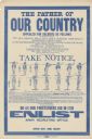
| Date: | 1917 |
|---|---|
| Description: | Poster featuring a reproduction of a Revolutionary War notice calling for soldiers. In addition to its text, this includes illustrations of soldier's posit... |
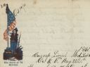
| Date: | 10 10 1861 |
|---|---|
| Description: | Letterhead of a Revolutionary War soldier standing and holding up the American flag in his right hand, and holding a rifle in his left hand. A plow is behi... |
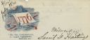
| Date: | 07 18 1861 |
|---|---|
| Description: | Letterhead with a rifle, sword, horn, and Revolutionary War-era hat surrounding a scroll reading: "1776." Text below the illustration reads: "The Old Conti... |
If you didn't find the material you searched for, our Library Reference Staff can help.
Call our reference desk at 608-264-6535 or email us at: