 Filter: Categories of Wisconsin Historical Images
Filter: Subject of Surveyors
Filter: Categories of Wisconsin Historical Images
Filter: Subject of Surveyors
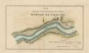
| Date: | 1840 |
|---|---|
| Description: | This map surveyed under the direction of Captain Thomas J. Cram is one in a series of seventeen that accompanied Cram's report on the Fox-Wisconsin river s... |
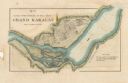
| Date: | 1840 |
|---|---|
| Description: | This map surveyed under the direction of Captain Thomas J. Cram is one in a series of seventeen that accompanied Cram's report on the Fox-Wisconsin river s... |

| Date: | 1840 |
|---|---|
| Description: | This map surveyed under the direction of Captain Thomas J. Cram is one in a series of seventeen that accompanied Cram's report on the Fox-Wisconsin river s... |

| Date: | 1840 |
|---|---|
| Description: | This map surveyed under the direction of Captain Thomas J. Cram is one in a series of seventeen that accompanied Cram's report on the Fox-Wisconsin river s... |
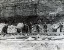
| Date: | 1945 |
|---|---|
| Description: | A group of men laying rails at Hawkins Mine while a man in the background is using surveying equipment near the base of a cliff face. |

| Date: | 1850 |
|---|---|
| Description: | Ink on paper. Shows local streets and Pekatonika River. "John M. Keep, proprietor. "Original plat of Darlington as surveyed by Richardson on June 14, 1850.... |

| Date: | 1856 |
|---|---|
| Description: | This map of Woodman's Addition in Mineral Point is pen-and-ink on paper. The map includes certifications signed by John B. Whitelaw (surveyor), Cyrus Woodm... |

| Date: | 06 1845 |
|---|---|
| Description: | This map is pen-and-ink on paper and shows the numbers, dimensions, and acreages of lots, as well as survey monuments and streets. Also included is a certi... |
| Date: | 1935 |
|---|---|
| Description: | One man is sighting a transit level, and another man is holding a round metal post as a crew of six people "sets a corner" in a Jackson County forest. Ther... |
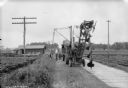
| Date: | 08 09 1927 |
|---|---|
| Description: | View along side of dirt road towards men installing telephone poles with a large drill. A group of of children are sitting on a pile of wood watching near ... |
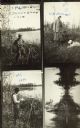
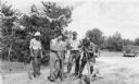
| Date: | |
|---|---|
| Description: | Four scenes of Trout Lake. The top left shows a man surveying on the shoreline of a lake. Handwritten text reads: "PA. MacDonald, Trout Lake 1910." The top... |
If you didn't find the material you searched for, our Library Reference Staff can help.
Call our reference desk at 608-264-6535 or email us at: