 Filter: Categories of Wisconsin Historical Images
Filter: Subject of Voyages and travels
Filter: Categories of Wisconsin Historical Images
Filter: Subject of Voyages and travels

| Date: | 04 15 1930 |
|---|---|
| Description: | Outdoor group portrait of the Logan African Expedition, Berriche, Algeria. Six men and a toddler are crouching or kneeling in the foreground. Behind them m... |
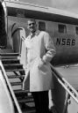
| Date: | 04 06 1960 |
|---|---|
| Description: | A man (Henry Derleth) wears an overcoat while posed on the middle of the boarding stairway attached to a partially visible passenger airliner. The original... |

| Date: | 04 07 1960 |
|---|---|
| Description: | Contest winner George Byrne, surrounded by his family, wears an overcoat, white shirt, tie and fedora (hat) while holding a TWA travel bag. The original ca... |
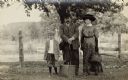
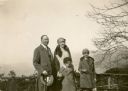
| Date: | 1900 |
|---|---|
| Description: | Group portrait of George, Louise, and Milton, their son, standing in front of a fence. They are traveling with one suitcase and a full handbag. All three a... |
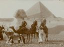
| Date: | 01 1909 |
|---|---|
| Description: | Three men in western dress riding camels pose with their Egyptian guides in front of the Sphinx at the Giza necropolis, with the Cheops pyramid in the back... |
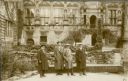
| Date: | 03 14 1930 |
|---|---|
| Description: | Ernst Schmidt, second from left, on a tour of the ruins of Heidelberg Castle with his guide, left, and two unidentified persons. They are standing in the c... |
| Date: | 02 22 1930 |
|---|---|
| Description: | William Conrad Seipp, Jr., left, and his daughter Melita, far right, pose with Alma Schmidt Petersen and her son Conrad at an overlook above Portofino Bay.... |
| Date: | 1935 |
|---|---|
| Description: | Original created in 1788, this facsimile map shows the routes traveled by Perrault, an early voyageur in Northern America. |
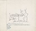
| Date: | 08 05 1820 |
|---|---|
| Description: | Sketches of Native American marks in James Doty's travel journal. Most of the marks represent different types of fish. |
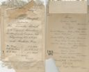
| Date: | 1883 |
|---|---|
| Description: | Menu for a reception and banquet for "Hon. Alexander Mitchell by the Citizens of Milwaukee on his return from his European Trip." At the top is a silk ribb... |

| Date: | 1775 |
|---|---|
| Description: | This map shows the northern Pacific Ocean along with north eastern Asia and western North America. The interior of Asia contains detailed engravings of pla... |

| Date: | 1790 |
|---|---|
| Description: | An updated and corrected version of Robert de Vaugondy's 1750 map "Amérique Septentrionale: Dressée sur les Relations les Plus Modernes des Voyageurs et Na... |

| Date: | 1788 |
|---|---|
| Description: | This map shows the north western coast of North America, including the southern coast of what will be Alaska and parts of the Aleutian Islands. It includes... |

| Date: | 1769 |
|---|---|
| Description: | Double hemispherical map showing the continents, islands, countries, and a few major cities of the world. The routes of a few explorers are depicted and la... |

| Date: | 1679 |
|---|---|
| Description: | Decorative and detailed map of the eastern half of North America. Regions, cities, colonies, Native America land, rivers, lakes and some nautical features ... |

| Date: | 1724 |
|---|---|
| Description: | Map showing the mountains, rivers, lakes, settlements, islands, and regions of North and South America. Characteristic of de L'Isle, this map is highly det... |

| Date: | 1684 |
|---|---|
| Description: | Map of North America showing some colonies, cities, rivers, lakes, and Native American land. Ship routes spread across both oceans, including one decorated... |

| Date: | 1713 |
|---|---|
| Description: | Map showing the regions explored by Robert de La Salle between 1681 and 1686, as well as the route La Salle, and later Henri Joutel, took, moving north fro... |

| Date: | 1775 |
|---|---|
| Description: | This six sheet large format map is one of the most informative maps of its time. It shows cities, Native American land, lakes, rivers, mountains, topograph... |

| Date: | 1777 |
|---|---|
| Description: | This important map highlights the frantic desire and search for the north west passage. It shows a few settlements and mountains in Russia, north west Amer... |
If you didn't find the material you searched for, our Library Reference Staff can help.
Call our reference desk at 608-264-6535 or email us at: