 Filter: Creator Name of Colton, J. H.

| Date: | 1861 |
|---|---|
| Description: | A map of Wisconsin showing cities, counties, major roads, railroads, and bodies of water. Includes an inset of the vicinity of Milwaukee. |
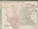
| Date: | 1861 |
|---|---|
| Description: | Colton's map showing Minnesota and the Dakotas. |

| Date: | 1855 |
|---|---|
| Description: | Drawn around 1855, this map shows the placement of railroad tracks in southern Wisconsin and northern Illinois connecting Milwaukee, Prairie du Chien, Gale... |

| Date: | 1853 |
|---|---|
| Description: | Wisconsin counties by color and shows railroads, common roads, canals, the state capital, county towns, townships, villages, and post offices, |

| Date: | 1854 |
|---|---|
| Description: | Map of the whole state Wisconsin includes an inset of the vicinity of Milwaukee, which shows the boundaries for Lisbon, Menomonee, Pewaukee, Brookfield, Wa... |

| Date: | 1855 |
|---|---|
| Description: | Map of Wisconsin, showing railway routes throughout the state as well as the names of the counties, townships, and cities in the state. The inset of the ma... |

| Date: | 1856 |
|---|---|
| Description: | A hand-colored map of Wisconsin, showing the county boundaries, towns, cities, railroads, roads, lakes, rivers, bays, and the Lake Superior’s islands. In ... |
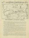
| Date: | 1857 |
|---|---|
| Description: | Map shows the railroads of southern Wisconsin, highlighting the Watertown and Madison Railroad. The Watertown and Madison Railroad between those two cities... |
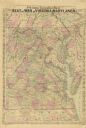
| Date: | 1865 |
|---|---|
| Description: | A general map of eastern Virginia, Maryland, Delaware, southern Pennsylvania, and northern North Carolina. |
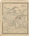
| Date: | 1860 |
|---|---|
| Description: | A hand-colored map showing the counties, major cities, ports, railroads, rivers and lakes in Wisconsin, Michigan, northern Illinois, and eastern Minnesota.... |

| Date: | 1856 |
|---|---|
| Description: | This map depicts the route of the La Crosse and Milwaukee Railroad in Wisconsin. Other railroads in Wisconsin, northern Michigan, and northern Illinois wit... |
If you didn't find the material you searched for, our Library Reference Staff can help.
Call our reference desk at 608-264-6535 or email us at: