 Filter: Creator Name of Gamble, W. H.
| Date: | 1870 |
|---|---|
| Description: | A hand-colored map of Wisconsin and Michigan detailing the states’ rivers, lakes, counties, town and cities. The map gives the greatest length, breadth, me... |

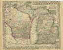
| Date: | 1877 |
|---|---|
| Description: | Two maps on one page, removed from an atlas. The first map shows Wisconsin and the upper peninsula of Michigan counties and townships while the second map ... |
If you didn't find the material you searched for, our Library Reference Staff can help.
Call our reference desk at 608-264-6535 or email us at: