 Filter: Creator Name of Harmon, George W., 1861-1942

| Date: | 1896 |
|---|---|
| Description: | This 1896 map of Washburn County, Wisconsin, shows the township and range grid, sections, schools, wagon roads, cities and villages, settlers, railroads, a... |

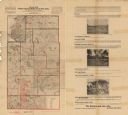
| Date: | 1909 |
|---|---|
| Description: | This 1909 revision of Harmon's 1896 map of Washburn County, Wisconsin, shows the township and range grid, towns, sections, schools, wagon roads, cities and... |

| Date: | 1916 |
|---|---|
| Description: | This 1916 map of Washburn County, Wisconsin, shows the township and range grid, sections, towns, schools, wagon roads, cities and villages, post offices, s... |
| Date: | 1900 |
|---|---|
| Description: | This map from the turn of the 20th century shows the township and range grid, sections, towns, land owned by the Starks Levis Land Company of Madison, scho... |
If you didn't find the material you searched for, our Library Reference Staff can help.
Call our reference desk at 608-264-6535 or email us at: