Filter: Creator Name of Madison (Wis.) City Planning Department
| Date: | 1965 |
|---|---|
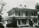
| Description: | The Executive Residence, 130 East Gilman Street. Used as the Executive Residence from 1883-1950. |
| Date: | 1965 |
|---|---|
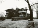
| Description: | The Eugene A. Gilmore house, 120 Ely Place, designed by Frank Lloyd Wright, architect. |

| Date: | 1965 |
|---|---|
| Description: | The Robert Lamp house, 22 North Butler Street (viewed from East Mifflin Street). The house was designed by Frank Lloyd Wright, architect, in 1902, and bui... |
| Date: | 1965 |
|---|---|
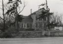
| Description: | Mapleside, 3500 University Avenue. This historic home was later demolished. |
| Date: | 1965 |
|---|---|
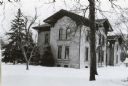
| Description: | The Simeon Mills (farm) house, 2709 Sommers Avenue. Snow is on the ground. |

| Date: | 1969 |
|---|---|
| Description: | Elevated view of State Street looking east towards the Wisconsin State Capitol. |
| Date: | 1965 |
|---|---|
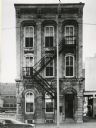
| Description: | View of the J.J. Stoner house, located at 321 South Hamilton Street. |

| Date: | 1965 |
|---|---|
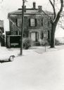
| Description: | Exterior view of the Strelow House, located at 218 North Pinckney Street. |

| Date: | 04 1945 |
|---|---|
| Description: | Topographic map of Park Lands in Glenwood Plat, Land for Glenwood Children's Park. Design by Jens Jensen. Oringinal drawing 35 x 34 inches. |

| Date: | 1967 |
|---|---|
| Description: | Shows projects and proposed projects, some zoning districts, public housing sites (Project Wis.-3-183-4), streets, and proposed streets. Upper left hand co... |

| Date: | 1938 |
|---|---|
| Description: | This map is blue line print and shows local streets, roads, the University of Wisconsin, Monona Village, Verona, Middleton, McFarland, Lake Mendota, Lake M... |

| Date: | 1959 |
|---|---|
| Description: | This map shows wards and precincts by number, local streets, roads, parks, Shorewood Hills, Maple Bluff, Middleton, Verona, McFarland, Monona, Truax Field,... |
If you didn't find the material you searched for, our Library Reference Staff can help.
Call our reference desk at 608-264-6535 or email us at: