 Filter: Creator Name of Milwaukee Journal Tour Club.

| Date: | 1925 |
|---|---|
| Description: | This map shows state trunk highways, county trunk highways, railroads, canoe trails, lakes, and free public camp sites. The map on the reverse also shows a... |

| Date: | 1927 |
|---|---|
| Description: | This map shows highways, roads, a proposed annexation, street car lines, bus routes, local motor bus lines, a new high speed interurban, railroads, a propo... |
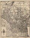
| Date: | 1924 |
|---|---|
| Description: | This map shows roads, cities, rivers,lakes, road surfacings and camp sites. Included are portions of Minnesota, Iowa, Illinois, and Michigan. Includes a le... |

| Date: | 1925 |
|---|---|
| Description: | This map shows road surfacing, camp sites, rivers, lakes, county boundaries, and cities. Original caption reads, "Compliments Hotel Witter Tour Information... |
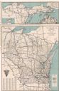
| Date: | 1928 |
|---|---|
| Description: | This map shows U.S., state, county highways, cities, county boundaries, lakes, rivers, and points of interest. At the top of the map it shows the Upper Mic... |
If you didn't find the material you searched for, our Library Reference Staff can help.
Call our reference desk at 608-264-6535 or email us at: