Filter: Community of Kewaskum

| Date: | 1878 |
|---|---|
| Description: | Bird's-eye map of Kewaskum. Includes a list of hotels, churches, post office, railroad depot, etc. |
| Date: | 1905 |
|---|---|
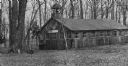
| Description: | North Side Park building. There is a bell tower above the entrance. |

| Date: | 04 07 2006 |
|---|---|
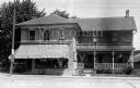
| Description: | "Scoot Pastorius is shown with our Fish Fry's outside of J.O.'s, at 334 Main Street, Kewaskum. J.O.'s is primarily a take-out business." |
| Date: | 02 19 2010 |
|---|---|
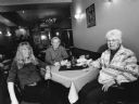
| Description: | "Victoria's Cornerstone Inn, 109 Main Street, Kewaskum. This was formerly Gateway Supper Club and Woody's Steak House." Ralph "Buddy" Ruecker and Shirley W... |
| Date: | 02 19 2010 |
|---|---|
| Description: | "Victoria, the owner, was our waitress at Victoria's Cornerstone Inn, Kewaskum." From left to right; Victoria, Ralph "Buddy" Ruecker, and Shirley Widmer. |

| Date: | |
|---|---|
| Description: | Letterhead of the Kewaskum Mutual Fire Insurance Company of Washington County, Wisconsin, with a Native American man wearing buckskin clothes and leggings ... |
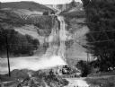
| Date: | 06 1984 |
|---|---|
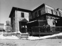
| Description: | "Reconstruction work is being done on Hwy 28, between Kewaskum and Hwy 41. This view is from the intersection of 28 and 41, looking due east." |

| Jim Widmer's "Spirit of Rural Wisconsin," Part II |
|---|
| Explore Jim Widmer's photographs of the Friday fish fry dinner tradition in Wisconsin. |

| Date: | 05 2000 |
|---|---|
| Description: | Kandy Lindgren photographs her daughter at a track meet in Kewauskum. |
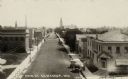
| Date: | 1851 |
|---|---|
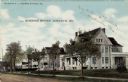
| Description: | Elevated view of a central street lined with businesses. Automobiles are parked at the curbs. There is a large building with columns on the left near an op... |
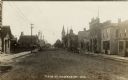
| Date: | 1914 |
|---|---|
| Description: | Photographic postcard view down unpaved Main Street. There is a print shop and a hotel on the left, and a dentist's office and a barber shop on the right. ... |
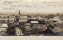
| Date: | 1907 |
|---|---|
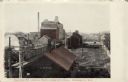
| Description: | Elevated view over the rooftops of a small town. There is a church in the center. On the far right a church is under construction. |
| Date: | 1908 |
|---|---|
| Description: | Elevated view of the central business district. A church is behind a row of businesses on the left. Hitching posts are along the sidewalk, with a horse-dra... |
| Date: | 1910 |
|---|---|
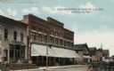
| Description: | View across street towards a block lined with businesses. The Eagle Hotel on the left, and horse-drawn vehicles are on the right. Caption reads: "Looking N... |
| Date: | |
|---|---|
| Description: | Elevated view of a street next to the train depot. A train is on the left, and a mill and grain company is in the background. Caption reads: "Railroad St. ... |
| Date: | 1910 |
|---|---|
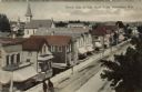
| Description: | View across a tree-lined residential street, that is unpaved, towards two-story homes with porches and balconies. Caption reads: "Residence District, Kewas... |
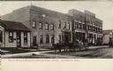
| Date: | |
|---|---|
| Description: | Photographic postcard view of a city block, with a store, a hotel and a few other businesses. Horses and buggies are parked at the curb. Caption reads: "Ea... |
If you didn't find the material you searched for, our Library Reference Staff can help.
Call our reference desk at 608-264-6535 or email us at: